Download
3D Flyover
Add to list
More
3.9 km
~1 hrs 17 min
313 m
Out and Back
“A short, sharp climb from city edge to wild moorland, crowned by sweeping Pentland panoramas.”
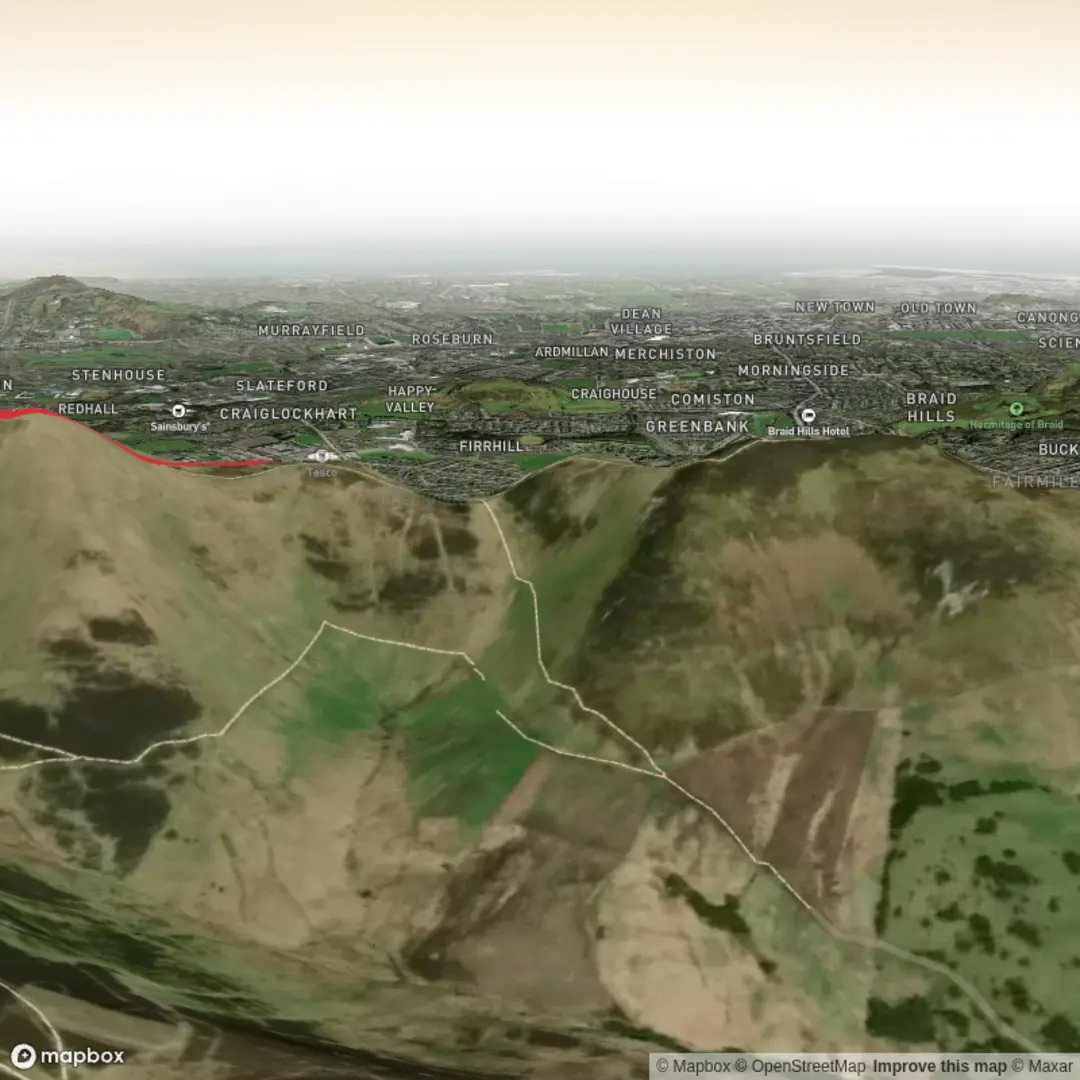
This short but steep outing climbs one of the most prominent northern Pentland summits above Edinburgh, packing a lot of ascent into roughly 4 km / 2.5 miles. Even though the distance is modest, around 300 metres / 985 feet of climbing makes it feel much more demanding than the mileage suggests, especially if you take a direct line to the top. Allermuir Hill rises to about 493 metres / 1,617 feet and is known for its broad views over Edinburgh, the Firth of Forth, and deeper into the Pentland Hills. (undiscoveredscotland.co.uk)
The most practical start for a short ascent is near the Midlothian Snowsports Centre at Hillend, just south of Edinburgh. A commonly used trailhead is the lower car park below the snowsports centre, near the A702 turnoff, which Walkhighlands identifies as the start for its Allermuir Hill route. That places the hike start near the Midlothian Snowsports Centre, Hillend, Edinburgh, rather than an unnamed point. (walkhighlands.co.uk)
Expect a tough opening. The path climbs quickly above the ski slopes and gains height with very little easing off, so this route suits hikers who are comfortable with sustained uphill walking on exposed ground. Underfoot, the trail is generally a mix of hill path, stony sections, and potentially rough or wet patches, with some muddier ground after rain. If the weather is windy, the upper slopes can feel much harsher than they do from the car park. (walkhighlands.co.uk)
What the route feels like
From the Hillend side, the first section usually heads diagonally uphill on a clear path above the road and ski area. Within the first 1 km / 0.6 miles, you will already have gained a substantial amount of height, and the city begins to open out behind you. If you include the nearby rise of Caerketton Hill before continuing to Allermuir, the route becomes more undulating and more strenuous than the raw distance suggests. Walkhighlands’ longer version via Caerketton is 6 km / 3.75 miles with 385 metres / 1,263 feet of ascent, which helps explain why even shorter variations still feel hard. (walkhighlands.co.uk)
The final approach to Allermuir Hill is usually the most memorable part of the climb: a steep pull to the summit ridge, where fences, open moorland, and a more rugged hill character replace the lower access paths. The summit itself is marked by a trig point and a viewpoint indicator. On a clear day, this is one of the best easily reached viewpoints on the edge of Edinburgh, with the city spread out to the north and the higher Pentland summits stretching away to the southwest. (walkhighlands.co.uk)
For a hike of around 4 km / 2.5 miles, many walkers either go up and back by the same line or make a compact loop using connecting paths toward Swanston or the lower slopes. If planning your route in advance, HiiKER is the best tool to check exactly which variation matches your intended distance and ascent.
Landmarks, scenery, and wildlife
One of the defining visual features of this hike is the contrast between the urban edge and open upland terrain. You start close to the developed slopes of the snowsports centre, then quickly move into the rolling moorland character that defines the Pentland Hills Regional Park. The wider park landscape includes upland heather moorland, reservoirs, and pockets of woodland, so even on a short route you get a strong sense of leaving the city behind. (pentlandhills.org)
The summit views are the main reward. Looking north, Edinburgh dominates the skyline; looking west and south, the eye follows the Pentland ridge toward hills such as Carnethy Hill, Scald Law, and East and West Kip. These long sightlines are a major reason Allermuir is so popular despite the steep climb. (walkhighlands.co.uk)
Wildlife varies with season and time of day, but the Pentlands are known for moorland birds and mammals including deer. Regional Park information notes heather moorland and wildlife interest across the area, and species lists for the park include birds such as kestrel; other local summaries mention roe deer, skylarks, lapwings, meadow pipits, and grouse in the wider hills. (pentlandhills.org)
Because this is open hill country, conditions can change quickly. Low cloud can reduce visibility on

Comments and Reviews
User comments, reviews and discussions about the Allermuir Hill, Scotland.
average rating out of 5
0 rating(s)