Download
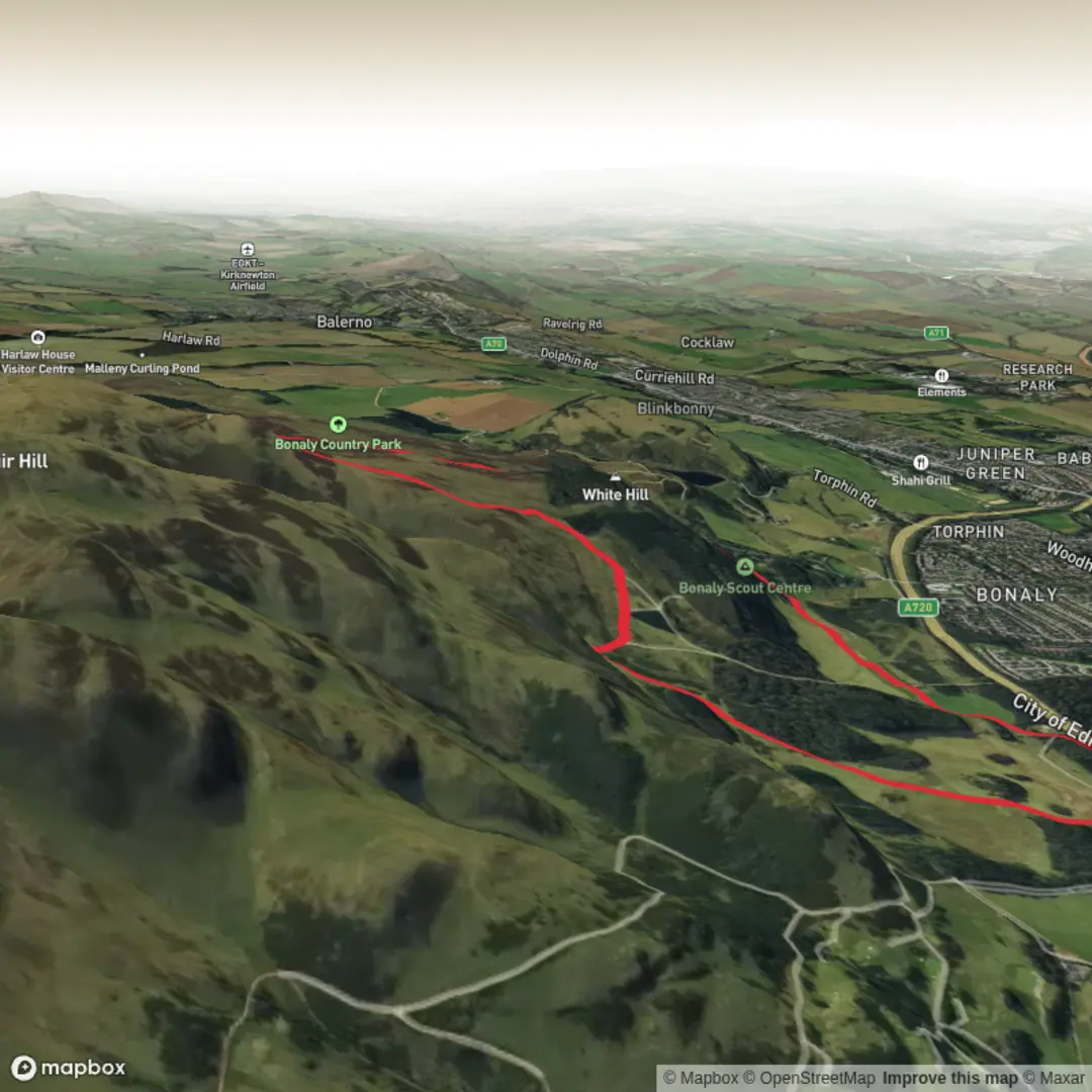
3D Flyover
Add to list
More
6.4 km
~1 hrs 41 min
246 m
Loop
“A rewarding Pentlands loop blending shady woods, breezy slopes, reservoir calm, and sweeping Edinburgh views.”
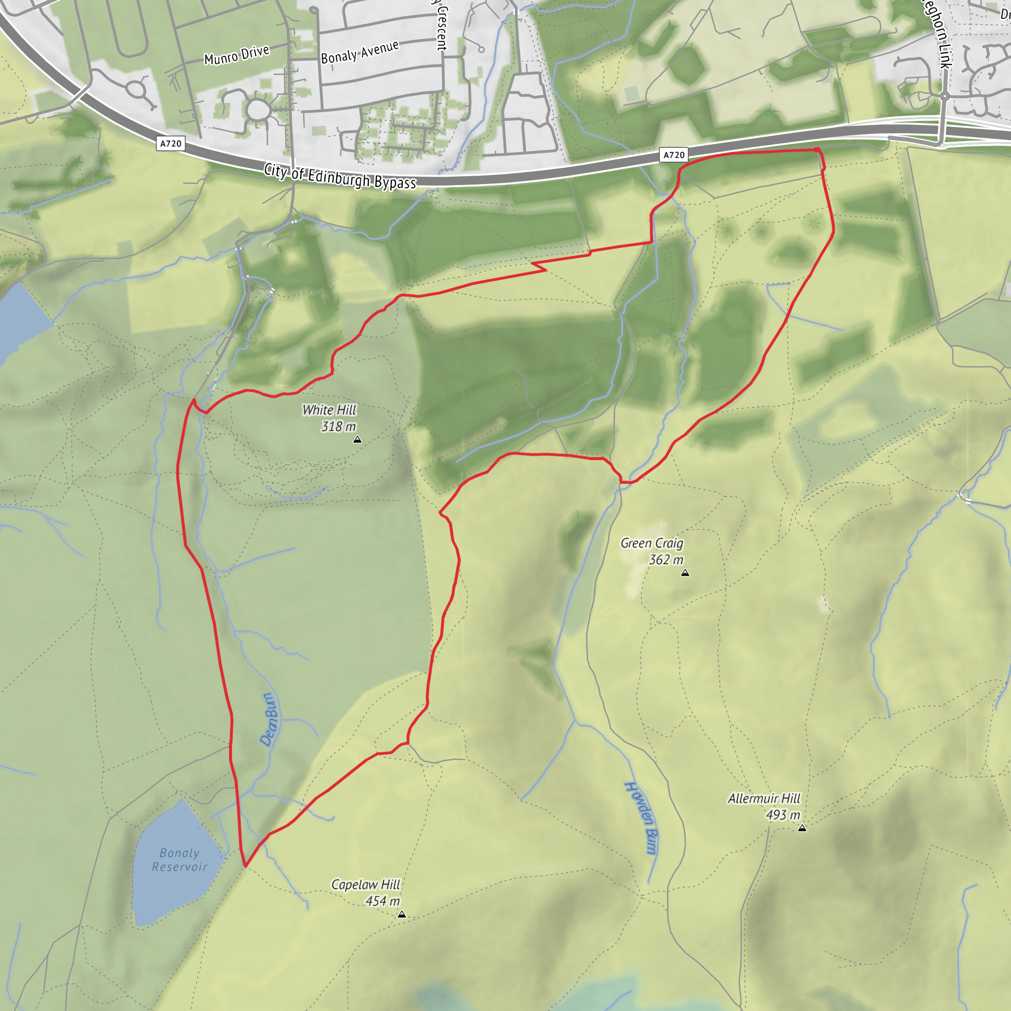
This roughly 6 km (3.7 mile) loop in the northern Pentland Hills gives a very satisfying mix of woodland approach, open hillside, reservoir scenery, and broad views back toward Edinburgh. With around 200 metres (about 656 feet) of ascent, it feels like a proper half-day hill walk without becoming overly long, and the “medium” rating fits well: the distance is modest, but there are steady climbs, exposed sections in poor weather, and some uneven, sometimes muddy ground. The route is best suited to walkers with decent footwear and a basic level of hill fitness. (pentlandhills.org)
The usual starting point is Bonaly Country Park upper car park, Bonaly Road, Edinburgh EH13 0PB, near the northern entrance to the Pentland Hills Regional Park. That is the nearest clear landmark and access point for this walk. If you are arriving by car, Bonaly is one of the main official access points into the regional park, though parking can fill quickly at busy times. If you are using public transport, the most practical option is typically the Lothian Buses service 10 to Bonaly, followed by a short uphill walk to the country park entrance and car park area. The wider park authority also encourages visitors to use public transport where possible because of parking pressure at popular trailheads. (pentlandhills.org)
The opening section usually heads out from Bonaly Country Park on broad paths through mixed woodland and open parkland, easing you into the route before the climb steepens. This lower ground is often sheltered, and after rain it can be soft underfoot, especially where paths collect runoff. Early on, the route begins to reveal one of the defining contrasts of the Pentlands: behind you lies the edge of Edinburgh, while ahead the landscape quickly becomes more upland and spacious. Even on a short loop, that transition is one of the walk’s biggest strengths. (goorienteering.org.uk)
Climbing toward White Hill
As the route rises toward White Hill, the gradient becomes more noticeable, with the main ascent accounting for most of the day’s 200 metres (656 feet) of climbing. On a 6 km (3.7 mile) circuit, that means the uphill effort is concentrated enough to raise the heart rate, but not so prolonged that it becomes a major mountain day. Expect a mixture of estate-style tracks, hill paths, and rougher sections where boots are preferable to trail shoes in wet conditions. In mist, the open hillside can feel much bigger than the map suggests, so checking the route on HiiKER before setting out is worthwhile. (edinburgh.gov.uk)
White Hill itself is not among the highest Pentland summits, but it is an excellent viewpoint for a shorter outing. As height is gained, views open north and northeast across Edinburgh and beyond, while the surrounding Pentland ridges begin to frame the walk more clearly. On a bright day, this section can feel expansive and airy; in wind or low cloud, it becomes a more serious hill environment, so an extra layer and waterproof shell are sensible even for a relatively short route. (edinburgh.gov.uk)
Reservoir, landscape, and what to notice
The loop’s other major feature is Bonaly Reservoir, set on the northwestern slopes of the Pentlands at roughly 350 metres above sea level. The reservoir gives the walk a strong sense of place, combining engineered history with a distinctly natural setting. It was built as part of Edinburgh’s water infrastructure, serving both as a freshwater supply and as a compensation reservoir to help maintain downstream flows. That makes it more than just a scenic water body: it is part of the long story of how the city relied on the Pentlands for water management. (en.wikipedia.org)
The surrounding landscape also carries older traces of human activity. The Bonaly area has a long history of settlement, and nearby remains include evidence of prehistoric occupation, including an Iron Age hillfort in the wider area around Clubbiedean. While this particular loop is mostly appreciated for its scenery and accessibility, it sits within a landscape shaped over centuries by farming, water engineering, estate management, and movement between the city fringe and the hills. (en.wikipedia.org)
Nature on this route changes noticeably with elevation. Lower down, woodland edges and scrub can hold common songbirds, while the more open hill ground is better for watching skylarks in season and scanning for raptors overhead. Around the reservoir and wetter margins, expect typical upland-edge plant communities, rough grasses, rushes, and heathery patches higher up. Mammals are usually elusive, but rabbits and deer are possible, especially in quieter hours. As with many popular Pentland access routes, dogs, runners, and mountain bikers may also be encountered, so it helps to stay aware on shared paths. (goorienteering.org.uk)
Because
Surfaces
Unknown
Gravel
Dirt
Grass
Ground
Asphalt
Unpaved
Comments and Reviews
User comments, reviews and discussions about the Bonaly Reservoir and White Hill Loop, Scotland.
average rating out of 5
0 rating(s)
