Download
Preview
Add to list
More
9.8 km
~3 hrs 1 min
647 m
Loop
“A compact yet fierce Coigach round, where wild moor, stern crags, and Sgòrr Tuath steal the day.”
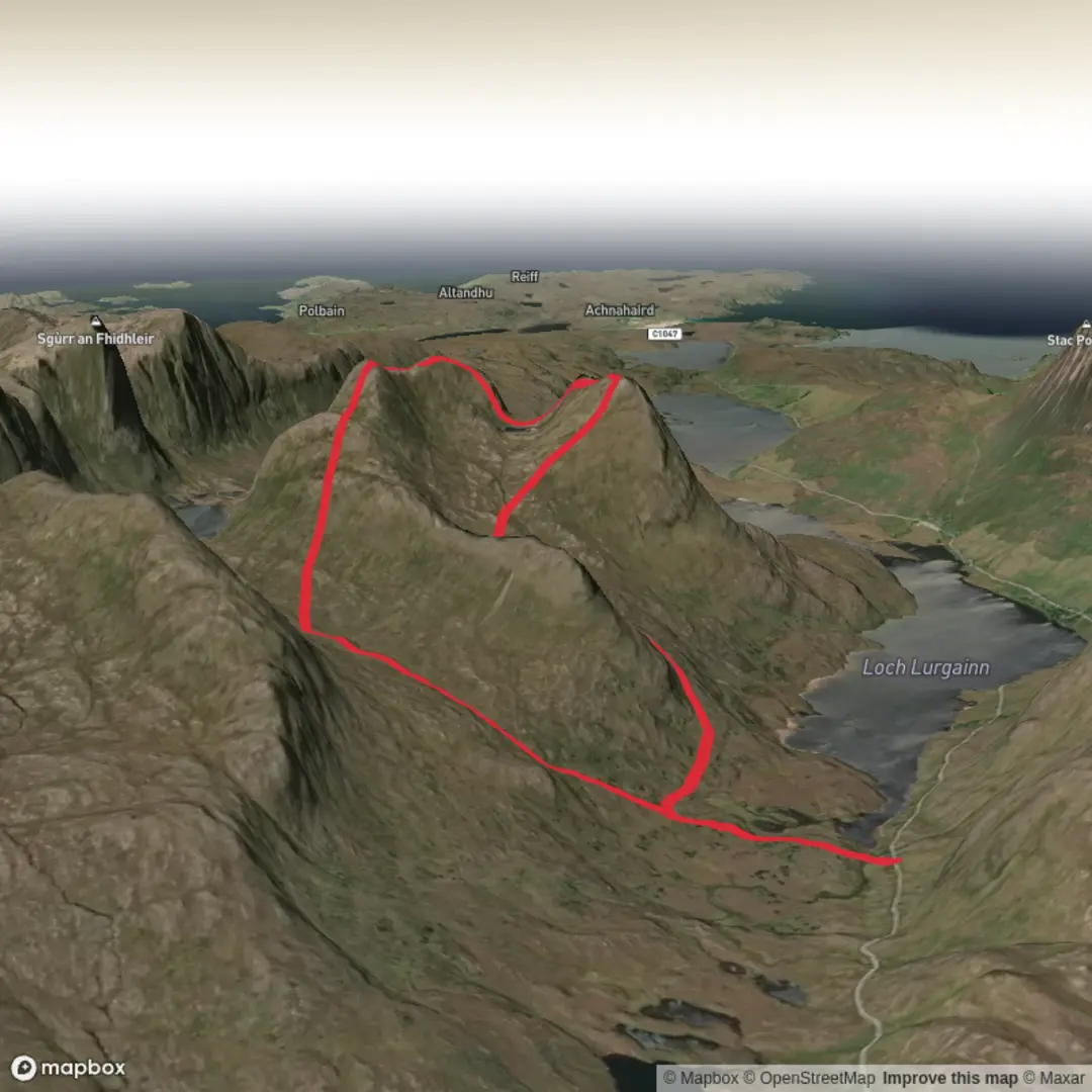
This is a short but serious hill day in Coigach, north of Ullapool, taking in Beinn an Eoin and its striking northern outlier, Sgòrr Tuath. Although the round is only about 10 km / 6.2 miles, the roughly 700 m / 2,300 ft of ascent is packed into steep, rough Highland terrain, so the “Difficult” rating is well deserved. Beinn an Eoin itself rises to 619 m / 2,031 ft and is known for its long western crags, while Sgòrr Tuath gives the route a sharper, more dramatic finish. The nearest settlement is Strathkanaird, and the mountain sits in the Coigach area of the Northwest Highlands, north of Ullapool. (en.wikipedia.org)
The start is best described as being near Strathkanaird Road End on the Achiltibuie road, a small roadside stopping point north of Ullapool rather than a formal large trailhead. Strathkanaird is a remote crofting township about 7 miles / 11 km north of Ullapool, and most walkers approach from the roadside near the township rather than from a built visitor facility. (en.wikipedia.org)
By car, the usual approach is from Ullapool on the coastal road toward Achiltibuie, watching for the Strathkanaird road end area and parking considerately without blocking passing places, gates, or local access. This is a quiet single-track road environment, so an early start is useful both for space and for a calmer walk-in. Public transport is limited but possible with planning: D&E Coaches service 811/811A serves Strathcanaird/Strathkanaird Road End from Ullapool on school days, with timetable entries showing stops at Strathcanaird Road End and Ullapool. Because services are infrequent and timetable patterns vary by day, it is important to check the latest service before committing to a bus-based hike. (decoaches.co.uk)
The route is typically tackled as a compact circuit of about 5.5 miles / 8.9 km to 10 km / 6.2 miles, depending on the exact line taken. The first section is usually the least dramatic but should not be underestimated: expect wet ground, rough moorland, and only intermittent path definition before the climb steepens. This is not a groomed hill path. Even in good weather, the ground can be peaty and uneven, and after rain it can become slow going. The ascent then bites hard, gaining height quickly onto the broad upper mountain. (plotaroute.com)
On the ascent
Once above the lower moor, the character changes from boggy approach to open hill ground with increasingly wide views over Coigach. Beinn an Eoin is often described as one of the less-frequented Graham summits in the area, and that relative quiet is part of the appeal. The western side is defended by long crags, so the mountain feels much more rugged than its height alone suggests. In poor visibility, the broad upper ground can be confusing, especially if you intend to continue on to Sgòrr Tuath, so careful line-finding matters. If you use digital navigation, HiiKER is the tool to have ready before setting out. (walkhighlands.co.uk)
From the main summit, the continuation to Sgòrr Tuath is one of the highlights of the day. Sgòrr Tuath stands out as a distinct subsidiary peak to the north, and the traverse gives the outing a more adventurous feel than a simple up-and-down ascent. The ground between tops can feel awkward underfoot, with rocky sections and route choices that become more consequential in mist or strong wind. This is a route where distance can be deceptive: 10 km / 6.2 miles on paper may feel much bigger because of the terrain, exposure, and concentration needed. (en.wikipedia.org

Comments and Reviews
User comments, reviews and discussions about the Beinn an Eoin and Sgorr Tuath, Scotland.
average rating out of 5
0 rating(s)