Download
3D Flyover
Add to list
More
122.5 km
~5 days
2857 m
Multi-Day
“Traverse the Great Glen Way for an unforgettable Highland adventure, steeped in natural beauty and Scottish heritage.”
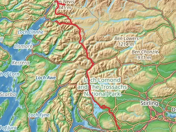
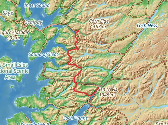
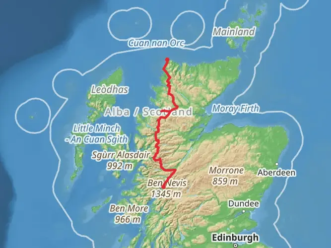
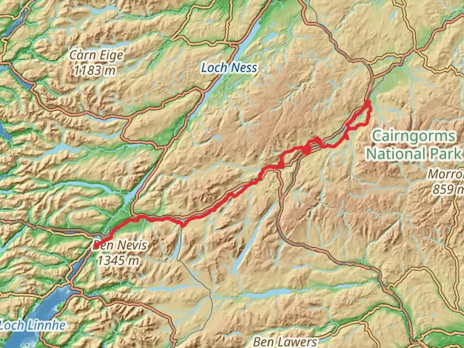
Spanning approximately 122 kilometers (76 miles) with an elevation gain of around 2800 meters (9186 feet), the Great Glen Way carves a scenic route through Scotland's iconic Highland landscapes. This point-to-point trail begins near the bustling town of Fort William, situated at the base of Britain's highest peak, Ben Nevis.
Getting to the Trailhead
To reach the starting point of the Great Glen Way, hikers can travel to Fort William by car or public transport. The town is well-connected by bus and train services from major cities like Glasgow and Edinburgh. For those driving, parking is available in the town, allowing for a convenient start to the hike.
Fort William to Gairlochy
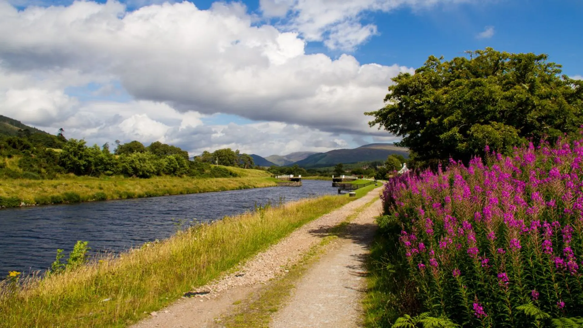
The trail kicks off with a gentle start, meandering along the Caledonian Canal and offering hikers views of the tranquil waterways and the surrounding mountains. This initial stretch is approximately 17 kilometers (10.5 miles) and leads to the small settlement of Gairlochy.
Gairlochy to Laggan
Continuing from Gairlochy, the path follows the shores of Loch Lochy. This section, around 23 kilometers (14 miles), is where hikers can immerse themselves in the natural beauty of the loch and its wooded fringes. Keep an eye out for native wildlife such as red deer and golden eagles.
Laggan to Fort Augustus
The trail then progresses towards Fort Augustus, covering a distance of about 17 kilometers (10.5 miles). This segment offers a mix of forest trails and open landscapes, with the chance to spot the elusive Scottish wildcat. Fort Augustus itself is a charming village where the locks of the Caledonian Canal can be observed in action.
Fort Augustus to Invermoriston
From Fort Augustus, the Great Glen Way climbs to higher ground, providing expansive views over Loch Ness. This roughly 12-kilometer (7.5-mile) stretch to Invermoriston is where the trail begins to challenge hikers with steeper inclines.
Invermoriston to Drumnadrochit
The path to Drumnadrochit, about 23 kilometers (14 miles) away, continues along the hillside above Loch Ness. This is an excellent opportunity to scan the waters for the legendary Loch Ness Monster and to explore the ruins of Urquhart Castle, which holds centuries of history within its walls.
Drumnadrochit to Inverness
The final leg of the Great Glen Way, leading to the city of Inverness, is approximately 30 kilometers (18.6 miles). This section sees the trail ascend through forests and descend into the urban landscape of Inverness, the capital of the Highlands. Upon reaching Inverness, hikers can explore the city's historical sites, including Inverness Castle and the Old High Church.
Throughout the journey, hikers should utilize HiiKER for navigation and to track their progress along the trail. The app provides detailed maps and information on the route, ensuring a safe and enjoyable experience.
The Great Glen Way not only offers a physical challenge but also a journey through Scotland's rich history and stunning natural environments. With proper preparation, including suitable hiking gear and awareness of the weather conditions, this trail promises an unforgettable adventure through the heart of the Scottish Highlands.

What to expect?
Activity types
Frequently asked questions
How long does the Great Glen Way take to walk from Fort William to Inverness?
The Great Glen Way is 122.5 km, or about 76 miles, from Fort William to Inverness. Most walkers complete it in 5 to 7 days, usually by breaking the route into stages such as Fort William to Gairlochy, Fort Augustus, Invermoriston, Drumnadrochit, and Inverness. The route is widely described as a 79-mile coast-to-coast trail with staged walking between settlements along the glen.
Where does the Great Glen Way start and finish in Scotland?
The Great Glen Way starts at the Old Fort in Fort William and finishes in Inverness. It follows the Great Glen northeast through the line of the Caledonian Canal and past Loch Lochy, Loch Oich, and Loch Ness, linking two of the Highlands' main transport hubs.
Is the Great Glen Way hard, and are there steep sections on the route?
The Great Glen Way is generally considered a medium-difficulty multi-day trail. Much of the southern half follows lower-level canal towpaths, forest tracks, and lochside paths, but the route becomes more demanding north of Fort Augustus, where there are higher alternatives above Loch Ness with more climbing and broader views.
Can dogs walk the Great Glen Way?
Dogs are allowed on the Great Glen Way under the Scottish Outdoor Access Code. They need to be under close control throughout the route, and they should be kept on a lead where there are sheep and lambs. That makes the trail dog-friendly in principle, but livestock and long daily distances mean good control is important.
Are there high and low route options on the Great Glen Way near Loch Ness?
Yes. On the Loch Ness side of the Great Glen Way, sections between Fort Augustus and Invermoriston and between Invermoriston and the Altsigh area offer a choice between lower routes and higher routes. The high options involve more ascent but are known for some of the best views over Loch Ness and the Great Glen.
Can the Great Glen Way be reached by public transport at Fort William and Inverness?
Yes. Fort William and Inverness are both served by rail and long-distance bus, which makes the Great Glen Way straightforward to access without a car. Train services connect Glasgow with Fort William and Edinburgh with Inverness, and bus services run between Fort William and Inverness with stops in settlements along the route.
What kind of scenery does the Great Glen Way pass through?
The Great Glen Way crosses the Highland fault line from Fort William to Inverness, passing canal towpaths, forest tracks, old drove roads, and long loch shores. Key landmarks along the route include the Caledonian Canal, Loch Lochy, Loch Oich, Loch Ness, Fort Augustus, Invermoriston, and Drumnadrochit, with Ben Nevis rising near the Fort William end.
Comments and Reviews
User comments, reviews and discussions about the Great Glen Way, Scotland.
4.78
average rating out of 5
109 rating(s)