Download
Preview
Add to list
More
8.8 km
~2 hrs 27 min
419 m
Loop
“A breezy Pentland circuit rising from quiet waters to a sweeping, three-summit skyline.”
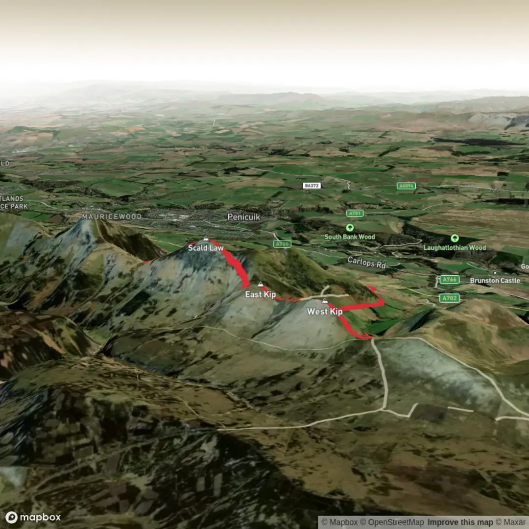
This medium-grade loop in the Pentland Hills packs a lot into roughly 9 km / 5.6 miles and about 400 m / 1,312 ft of ascent, with a steady build from reservoir-side tracks onto a high, open ridge linking three of the range’s best-known tops. The route is usually associated with the north-west side of the Pentlands near Threipmuir Reservoir car park, EH14 7JT, just south of Balerno, Edinburgh, which is the nearest clear access point for this circuit. The terrain is varied rather than technical: estate tracks and grassy paths at lower level, then steeper hill paths on the Kips, with rougher, sometimes boggy or wind-exposed ground higher up. Scald Law is the highest hill in the Pentlands at 579 m / 1,900 ft, while West Kip reaches 551 m / 1,808 ft and East Kip 534 m / 1,752 ft. (walkhighlands.co.uk)
From the start, the walk typically heads out past Radford Bridge and the waters of Threipmuir Reservoir, then follows a rising track toward the open moorland and the col below West Kip. Even early on, the character of the day is clear: broad skies, long views, and very little shelter once you leave the trees behind. The first few kilometres are a good warm-up, but the climb onto West Kip is the first real test, with a short, steep grassy pull that can feel much harder in wet or windy conditions. Walkers should expect the ascent profile to feel more demanding than the overall distance suggests. (walkhighlands.co.uk)
On the ridge
West Kip is often considered one of the shapeliest hills in the range, with a pointed profile and excellent views across the Lothians. From there, the ridge undulates eastward to East Kip, then continues toward Scald Law by way of a broad bealach and a rising traverse. Although the mileage between summits is not huge, this middle section is where the route feels most exposed. Strong winds are common on the Pentland Ridge, and the higher ground can be markedly colder than the car park, so extra layers, waterproofs, and careful timing matter even on a relatively short outing. If visibility drops, the broad tops and intersecting paths can feel less obvious than they do on a clear day, so carrying and checking the route on HiiKER is sensible. (walkhighlands.co.uk)
Scald Law’s summit is broader and less sharply defined than West Kip’s, but it is the high point of the Pentlands and is marked by a trig point. On a clear day, the panorama is one of the main rewards of the walk, with wide views over Edinburgh, the Lothians, and the surrounding hill country. The ridge itself is a major landmark within the regional park and forms part of the iconic skyline seen from much of the surrounding area. (walkhighlands.co.uk)
Descent and return
The return is commonly made by dropping off the ridge on older hill paths toward The Howe and through Green Cleuch, a narrower glen that gives the second half of the walk a different feel from the airy ridge above. This section can be softer underfoot, especially after rain, and stream crossings or damp ground may need a little care. The final stretch trends back toward the lanes and tracks near Bavelaw before returning across the reservoir approach to the car park. Even though the route is not especially long, the combination of steep ups and downs, exposure, and occasional boggy patches means sturdy footwear is a better choice than lightweight trainers for most conditions. (walkhighlands.co.uk)
Nature and wildlife
The Pentlands are a classic mix of heather moorland, rough grassland, burns, reservoirs, and upland glens, so the scenery changes constantly over a short distance. Around Threipmuir and the lower approaches, there is a good chance of seeing common water and woodland birdlife, while the open hills are better for upland species. In the wider

Surfaces
Gravel
Dirt
Asphalt
Unknown
Unpaved
Comments and Reviews
User comments, reviews and discussions about the Scald Law, East Kip and West Kip Loop, Scotland.
average rating out of 5
0 rating(s)