Download
Preview
Add to list
More
8.5 km
~2 hrs 24 min
419 m
Loop
“A compact, heather-clad circuit above Dufftown, blending airy views, ancient fort traces, and boggy hill character.”
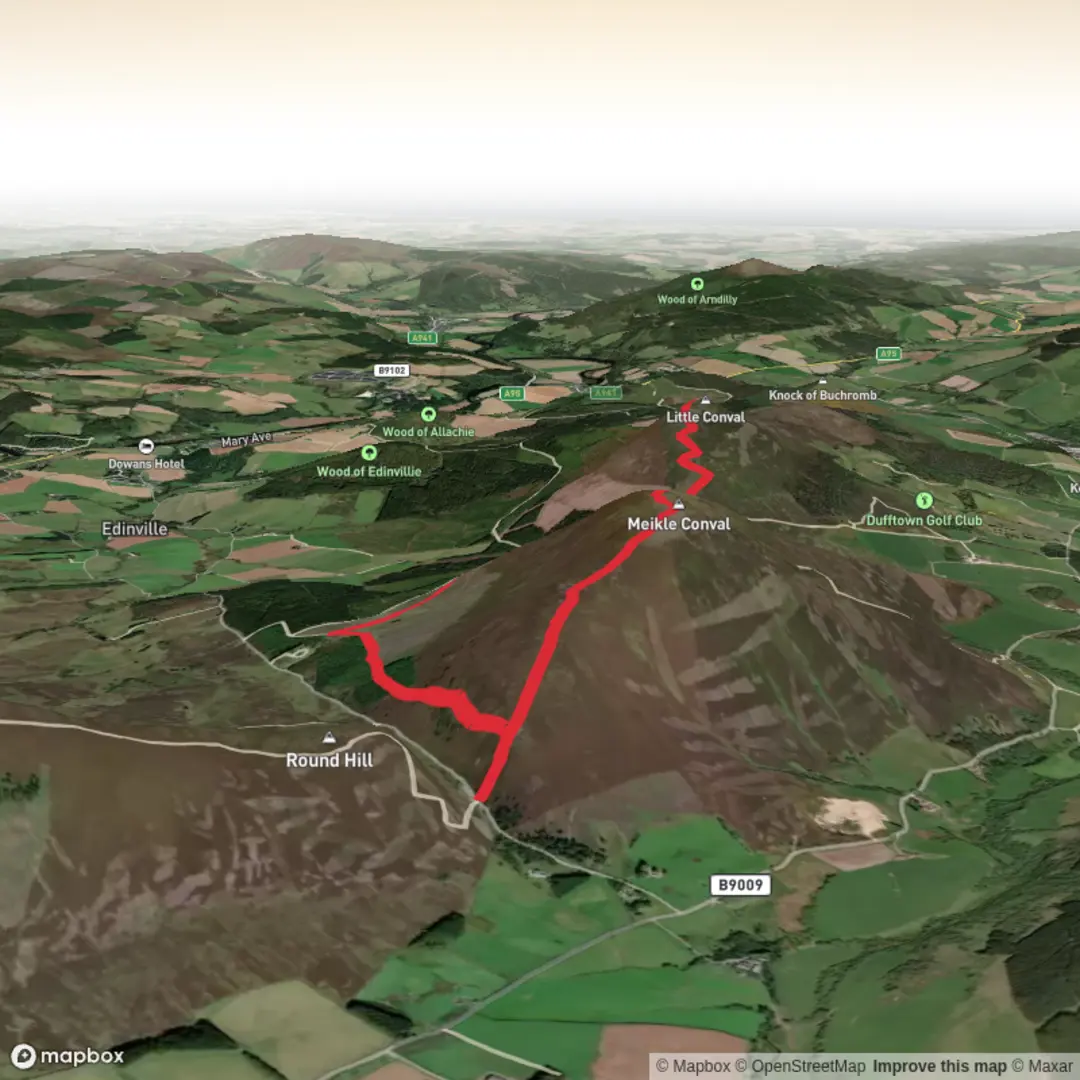
This medium-grade loop over the two Convals gives a compact but rewarding hill day above Dufftown, with roughly 9 km / 5.6 miles of walking and about 400 m / 1,312 ft of ascent. Expect a mix of town-edge paths, estate tracks, open moorland, and narrower hill paths that can be wet, peaty, and a little eroded in places. The terrain is straightforward in clear weather, but the exposed tops and the sometimes faint linking paths between the hills mean it still deserves proper hill preparation and careful route-finding with HiiKER. (walkhighlands.co.uk)
The walk starts near Dufftown Square, Dufftown, Moray, Scotland, which is the usual access point for the Convals route. A common roadside start is along the B9009 Tomintoul Road near Dufftown Golf Club, west of the town centre, where the route leaves the road and heads uphill toward the col between the two hills. (walkhighlands.co.uk)
From the start, the first section is gentle and practical rather than dramatic: leaving Dufftown, the route follows the B9009 west with an off-road path for part of the way before joining a track near the plantation edge. This opening stretch is useful for warming up, but it also means hikers should be ready for a little road walking and should take care with traffic where the separated path ends. As height is gained, the route moves onto grassy and sometimes wet ground, then into open heather moorland with broader views beginning to open behind you. (walkhighlands.co.uk)
On the ascent
The usual line reaches the saddle between the two hills before climbing Little Conval first. The path zigzags up the slope and is generally easy to follow, though shortcuts and worn lines can make the hillside look braided in places. Little Conval rises to about 552 m / 1,811 ft, and despite being the lower summit, it often feels like the more distinctive top because of its broad, flattened summit area and archaeological remains. (walkhighlands.co.uk)
One of the most significant landmarks on the route is the Iron Age fort on Little Conval. Remnants of its walls can still be traced across the summit in low stony banks and scattered piles, showing that this was once a substantial defended site with associated field systems. That gives the hill more than just scenic value: it was clearly important to people living in this part of Moray long before modern Dufftown and long before the whisky era for which the area is now famous. (walkhighlands.co.uk)
Views from Little Conval can be excellent in clear weather, stretching toward the Cairngorms, the Glenlivet hills, and north toward the Moray coast. Nearby Ben Rinnes dominates many of the outlooks and helps with orientation. The connecting path back to the col and onward to Meikle Conval can be slightly boggy and worn, so waterproof footwear is a sensible choice even on a relatively short outing. (walkhighlands.co.uk)
Meikle Conval is the higher of the pair at about 571 m / 1,873 ft. The climb from the col is not especially technical, but the ground can feel rougher and more exposed than the first ascent, especially in wind or after rain. The summit itself is marked by a small cairn. Because the hills are open and rounded rather than craggy, poor visibility can flatten the landscape and make bearings more important than many hikers expect on a medium-length route. (walkhighlands.co.uk)
What to expect underfoot and on the descent
The descent from Meikle Conval typically heads east on a faint damp path that becomes clearer lower down, eventually joining a track that zigzags past grouse butts before reaching the B9009 near Bridge of Convalleys, a small bridge on the road south of Ben Rinnes. From there, the route returns through farmland and minor roads toward Dufftown. (walkhighlands.co.uk)
That combination of hill path, estate track, and quiet road makes the loop varied, but it also means hikers should be prepared for changing pace and footing throughout the day. After wet weather, the peaty sections between and below the summits can hold water, and the grassy tracks can become slick. In warmer months, midges can also be a nuisance in still conditions, especially on

Surfaces
Ground
Unknown
Unpaved
Comments and Reviews
User comments, reviews and discussions about the Meikle Conval and Little Conval Loop, Scotland.
average rating out of 5
0 rating(s)