Download
Preview
Add to list
More
7.6 km
~1 hrs 56 min
253 m
Loop
“A breezy Border loop weaving steep grassy heights, old earthworks, and far-reaching views above Morebattle.”
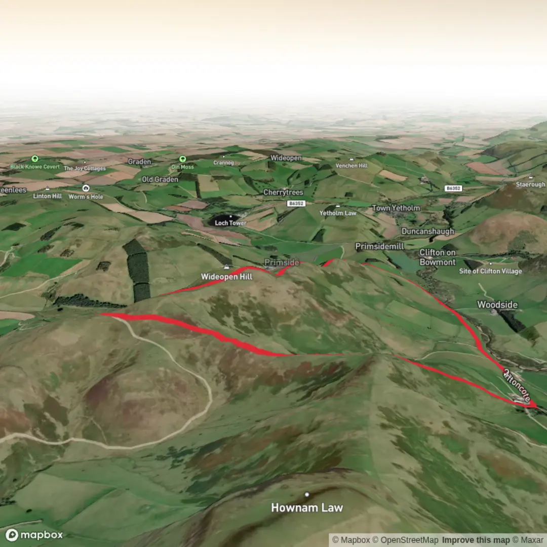
This medium-grade loop packs a lot into roughly 8 km / 5 miles, with about 300 m / 985 ft of ascent: a steady climb onto open Border hills, a ridge section with wide views, and a return through quiet pastoral country near Morebattle in the Scottish Borders. The hills sit on and around the line of St Cuthbert’s Way, and Wideopen Hill is widely noted as the highest point on that long-distance route, at around 400 m. Expect a mix of grassy hill paths, rougher trods, wall-side walking, gates and short stretches of minor road or farm track depending on the exact line used for the loop. (scotlandstartshere.com)
The most practical trailhead for this walk is Morebattle village, near Chairlie’s Vennel, Morebattle, Kelso, Scottish Borders, which is the nearest clearly identified access point and bus stop for the hill routes heading toward Grubbit Law and Wideopen Hill. Morebattle lies on the B6401, about 7 miles / 11 km south-east of Kelso beside the Kale Water. If arriving by car, roadside parking in or near the village is usually the obvious starting option, but it is best to park considerately and avoid blocking farm access or narrow lanes. By public transport, Scottish Borders Council’s Service 81 links Kelso and Morebattle, with stops at Morebattle, Chairlie’s Vennel. Timetables can change, so checking the latest service before travel is important. (scotborders.gov.uk)
The route normally begins with a gentle approach out of Morebattle before the main climb starts in earnest. Once beyond the village edge, the ground rises quickly toward Grubbit Law, and this first ascent is likely to feel like the hardest sustained effort of the day. On an 8 km circuit, most of the elevation gain is concentrated early, so hikers should be ready for a fairly direct uphill pull on grass and rough hill ground. In wet weather, the lower access fields and trods can be slippery, while the upper slopes can feel exposed to wind even on otherwise calm days. Walkhighlands specifically notes that the traverse of Wideopen Hill is more exposed in poor weather, which is worth taking seriously on a short hill day as much as on a longer crossing. (walkhighlands.co.uk)
On the climb and ridge
As height is gained, the character of the walk changes from enclosed farmland to open upland. The ridge linking Grubbit Law, Wideopen Hill, and Crookedshaws Hill is the defining feature of the outing. A number of route descriptions in the area mention following or crossing dykes and walls for navigation, and this is often how the line of travel is held across the tops. That makes the ridge relatively straightforward in clear conditions, but in mist the broad grassy ground can still be confusing, so carrying the route on HiiKER is sensible. (scotlandstartshere.com)
Grubbit Law is more than just a viewpoint. Historic records identify a linear earthwork on the neck of land associated with the hill mass of Wideopen Hill and Grubbit Law, showing that this landscape has been used and defended for a very long time. The surviving earthwork is described in the national historic environment record as crossing the neck between slopes and extending for roughly 180 m, with later tracks and roads cutting through it. That gives the ridge a strong sense of age: this is not only a walking landscape, but one shaped by centuries, and likely much longer, of movement, farming and boundary-making in the Border country. (trove.scot)
From Wideopen Hill, the views are one of the main rewards. Sources describing St Cuthbert’s Way repeatedly highlight the panorama from this section, with outlooks over the Cheviots and back across the Borders toward the Eildons on a clear day. Because the summit area is broad rather than dramatic

Comments and Reviews
User comments, reviews and discussions about the Grubbit Law, Wideopen Hill and Crookedshaws Hill Loop, Scotland.
average rating out of 5
0 rating(s)