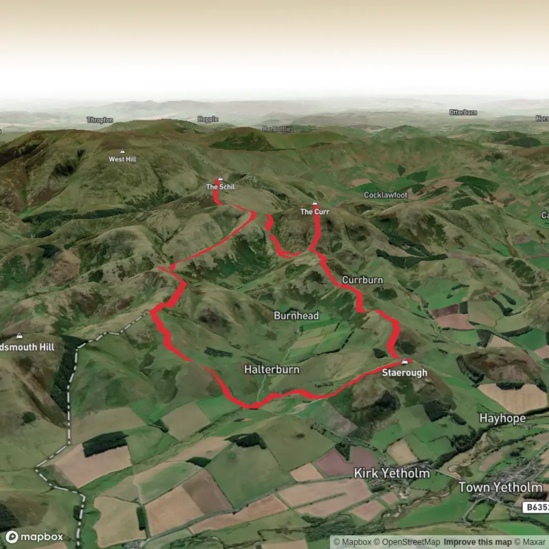
Staerough Hill, Sunnyside Hill, Wildgoose Hill, The Schil and Corbie Craig Loop via Pennine Way
Download
Preview
Add to list
More
15.8 km
~4 hrs 39 min
889 m
Loop
“A wild Cheviot circuit of rolling border hills, lonely ridges, and a haunting finish beneath The Schil.”
This loop explores the rounded border hills above Kirk Yetholm, linking the Pennine Way with a series of lesser-trodden tops before climbing to The Schil and swinging back by Corbie Craig. For a walk of around 16 km / 10 miles with roughly 900 m / 2,950 ft of ascent, it packs in a lot: long grassy ridges, broad moorland, a sustained mountain climb, and one of the most atmospheric finishing stretches anywhere near the northern end of the Pennine Way. Although the overall difficulty is often rated medium, the combination of repeated ups and downs, exposed ground, and the remoteness of the Cheviot border country makes it feel more serious than the numbers alone suggest. (en.wikivoyage.org)
The route is most naturally started near Kirk Yetholm, the village that marks the northern end of the Pennine Way, with the Border Hotel being the best-known landmark in the village and the traditional finishing point for end-to-end walkers. If you are arriving by car, parking in and around the Yetholm villages is limited, so it is worth planning ahead and using only clearly permitted parking areas. If you are coming by public transport, Kirk Yetholm is reached via Kelso, and Pennine Way transport guidance notes that services are limited, with no Kirk Yetholm–Kelso service on Sundays in the referenced timetable. Public toilets are noted at Town Yetholm, which is useful before setting out. (en.wikipedia.org)
From the village, the early part of the walk heads out on the Pennine Way and begins climbing almost immediately above the valley. The first ground is usually straightforward to follow, but the gradient builds steadily as you leave the last houses and enclosed fields behind. This opening section is a good place to settle into the day because the route gains height quickly and the views back over Kirk Yetholm and the lower Border country open up fast. In clear weather, the landscape feels spacious rather than dramatic at first, with rolling green-brown hills and long fence lines drawing the eye toward the Anglo-Scottish border. (nationaltrail.co.uk)
Terrain and route character
Staerough Hill, Sunnyside Hill and Wildgoose Hill are not high mountains in themselves, but they give this loop its rhythm. These are rounded upland tops rather than rocky summits, and they sit close together, creating a rolling traverse with frequent short climbs and descents. Summit references place Staerough Hill, Sunnyside Hill and Wildgoose Hill close to one another in the northern Cheviots, with Sunnyside Hill at about 327 m / 1,073 ft and Wildgoose Hill at about 336 m / 1,102 ft. That means the effort here comes less from altitude and more from cumulative ascent, uneven moorland footing, and the fact that the route never really lets you switch off. (mudandroutes.com)
Expect a mixture of grassy trods, engineered Pennine Way sections, wetter patches, and rougher hill paths. After rain, some of the lower and flatter sections can be soft underfoot, while the higher ground can feel surprisingly tiring if there is a strong wind. This is open country with little shelter, so even a modest forecast can feel harsher on the ridges. HiiKER is the navigation tool to rely on here, especially where the line of the route leaves the most obvious through-paths to collect the smaller hills before rejoining the main Pennine Way corridor.
The climb toward The Schil is the most mountain-like part of the day. The Schil rises to about 601 m / 1,972 ft and sits directly on the Pennine Way near the final Scottish stage of the trail. The approach is broader and grassier than a craggy peak ascent, but it is still a proper pull, especially if the ground is wet or the wind is blowing across the saddle. The summit area can feel bleak, open and very exposed, with a real sense of being out on the high border. (en.wikivoyage.org)
Landmarks, views and what to look for
One of the most distinctive features on the return side is Corbie Craig, a notable rock outcrop mentioned in National Trails material for the Border Ridge walk. It adds a more rugged visual note to a route otherwise dominated by smooth, whaleback hills and moorland folds. It is also a useful mental marker: once you reach this area, the character of the walk begins to shift from high, exposed upland travel

Surfaces
Unknown
Grass
Wood
Comments and Reviews
User comments, reviews and discussions about the Staerough Hill, Sunnyside Hill, Wildgoose Hill, The Schil and Corbie Craig Loop via Pennine Way, Scotland.
average rating out of 5
0 rating(s)