Download
Preview
Add to list
More
7.6 km
~1 hrs 43 min
114 m
Loop
“A lively loop above Callander pairs thunderous gorge drama with peaceful woods and ancient echoes.”
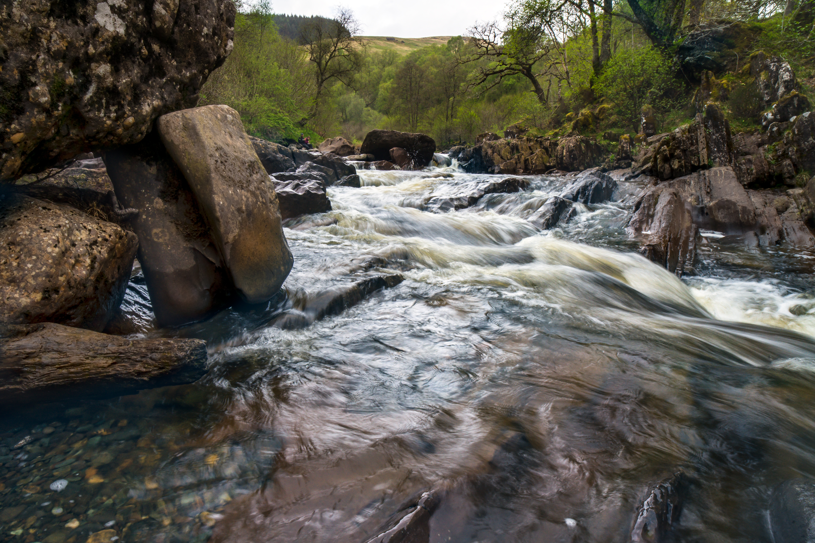
This easy loop above Callander combines a short woodland-and-gorge walk with a longer, gentler circuit through the edge of the national park, giving you a varied outing of about 8 km / 5 miles with roughly 100 m / 330 ft of ascent. The route is best known for Bracklinn Falls, where the Keltie Water cuts through a narrow rocky gorge, but it also passes quieter stretches of forest track, open views over the surrounding hills, and the remains of an ancient chambered cairn that add a strong sense of local history. The terrain is generally straightforward, but there are some steeper sections near the falls and occasional uneven ground, roots, and loose stones, so it is still worth wearing proper walking shoes rather than casual trainers. (lochlomond-trossachs.org)
The usual start is from the Bracklinn Road / Callander Crags area above the east end of Callander. A practical nearby address for navigation is Callander Crags Car Park, Bracklinn Road, Callander FK17 8EQ, which Forestry and Land Scotland lists as the nearest postcode for the signed parking area. From Callander’s Main Street, the access road is signposted uphill toward “The Crags” and “Bracklinn Falls,” about 500 metres from the east end of town. (forestryandland.gov.scot)
If arriving by car, Callander is reached from the A84, the main road running between Stirling and the central Highlands. Parking is commonly used either at Callander Crags car park or the higher Bracklinn Falls car park depending on the exact version of the loop you follow. Roads are narrow in places on the climb above town, and this is a busy visitor area in good weather, so arriving earlier in the day makes parking easier. (forestryandland.gov.scot)
If using public transport, the simplest approach is to take a bus to Callander from Stirling, then walk up through town to Bracklinn Road. Forestry and Land Scotland notes that buses between Stirling and Killin stop in Callander village, after which the trailhead is reached on foot by heading to the east end of Main Street and following the signed road uphill. For route-finding on the ground, HiiKER is the best tool to have ready before setting out. (forestryandland.gov.scot)
What the route feels like
The opening section is usually the most dramatic. From the car park, the path heads toward Bracklinn Falls on a good, obvious trail. This first part is popular with casual walkers because the surface is relatively friendly and the waterfall viewpoint is reached quickly. The gorge is the highlight: water funnels through dark rock walls and over broken slabs, creating a much wilder scene than the modest elevation gain might suggest. The bridge and viewing areas give excellent angles into the ravine, but this is also where extra care is needed, especially after rain when rock, timber, and compacted earth can all become slick. The drop beside the gorge is serious, and anyone with children should keep them close here. (lochlomond-trossachs.org)
Beyond the falls, the loop becomes quieter and more spacious. The path climbs a little more steeply through forest before easing out, and the rest of the walk tends to alternate between woodland paths, estate-style tracks, and more open stretches with views back toward Callander and the surrounding hills. Because the total ascent is only around 100 m / 330 ft on your described version, this is more of a scenic ramble than a strenuous hill walk, but the route still has enough variation to feel rewarding. Expect the full circuit to take roughly 2 to 3 hours at an unhurried pace, longer if you stop often at the falls or spend time exploring the historic features. (lochlomond-trossachs.org)
Landmarks, nature, and what to look out for
Bracklinn Falls is the signature landmark, and it owes much of its character to local geology. The falls lie where the river crosses the Highland Boundary Fault, the major geological line separating the Highlands from the Lowlands, which helps explain the abrupt rocky scenery around the gorge. Callander itself is often described as the gateway to the Highlands for the same reason. (en.wikipedia.org)
The chambered cairn adds a very different point of interest. This is one of the traces of much older settlement and ritual use in the area, linking the walk to the prehistoric landscape around Callander. The wider district has deep archaeological roots, with Neolithic burial cairns nearby and evidence of early

Surfaces
Unknown
Asphalt
Gravel
Grass
Comments and Reviews
User comments, reviews and discussions about the Chambered Cairn and Bracklinn Falls Loop, Scotland.
average rating out of 5
0 rating(s)