Download
Preview
Add to list
More
7.4 km
~2 hrs 8 min
396 m
Loop
“A lung-bursting climb above Killin rewards steady walkers with sweeping loch views and living Highland history.”
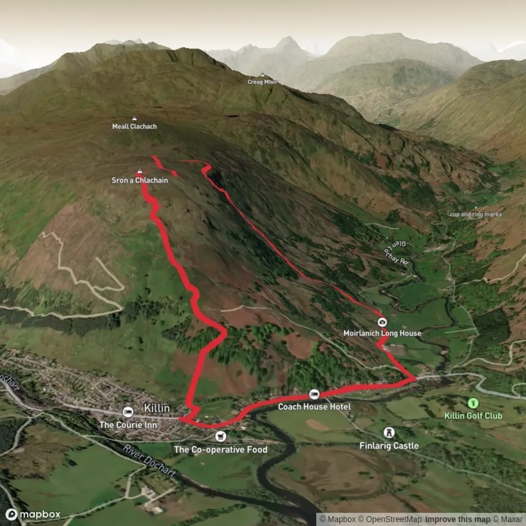
This medium-grade loop above Killin packs a lot into roughly 7 km / 4.3 miles: a steep climb of about 400 m / 1,312 ft to the rocky shoulder of Sròn a’ Chlachain, broad views over Loch Tay and the surrounding glens, and a return past one of the best-preserved surviving Highland longhouses in Scotland. The route combines a short but demanding hill section with a gentler finish, so it suits walkers who are comfortable with sustained uphill effort but do not necessarily want a full mountain day. The hill itself rises immediately west of Killin, and the longhouse lies about 1 mile / 1.6 km north-west of the village in Glen Lochay at Moirlanich Longhouse, Glen Lochay, Killin, Stirling FK21 8UA. (lochlomond-trossachs.org)
The walk usually begins from Killin, most commonly near McLaren Hall and Breadalbane Park, just off the village’s Main Street, which is the established access point for the climb onto Sròn a’ Chlachain. If you are driving, Killin is reached from Glasgow via the A82/A85 or via Stirling and the A84, and from Edinburgh via the M9 to Stirling and then the A84 toward Callander and Killin. There is also a small car park near Moirlanich Longhouse if you are planning the loop to pass or finish there. By public transport, buses serve Killin, though services are more limited outside the summer season; the nearest mainline rail stations are Crianlarich and Pitlochry, with onward bus connections. (lochlomond-trossachs.org)
The first part of the route is the hardest. From Breadalbane Park, the path heads through a gate and quickly begins climbing on a narrow, obvious hill path. Early on, you pass through a small area of oak woodland before the route steepens markedly under open hillside. Even on a relatively short outing, this ascent feels serious for its length, and the national park describes the standard climb as steep and strenuous, with uneven ground, loose material, and some boggy sections higher up. Good boots are advisable, especially after rain. Livestock may be present in the lower fields and sheep on the open hill, so care around animals and gates is important. (lochlomond-trossachs.org)
On the climb
As height is gained, the setting changes from woodland edge and rough grazing to more open heath and moorland. The reward is increasingly wide perspective: Killin below, Loch Tay stretching east, and the surrounding glens opening out in several directions. This is the feature that makes the route so popular despite the short, sharp ascent. On a clear day, the outlook over Loch Tay is one of the classic viewpoints in the area. Some route descriptions also note a detour to Fingal’s Stone, a local landmark associated in tradition with the burial place of the mythical giant Fingal, adding a layer of folklore to the climb. (lochlomond-trossachs.org)
The terrain near the top is more exposed than the lower slopes, and wind can be a bigger factor than many walkers expect on a 7 km / 4.3 mile outing. Low cloud can also reduce the sense of an obvious line once you leave the lower park and woodland behind, so carrying and checking your route on HiiKER is sensible even on a relatively compact hillwalk. In wet or windy weather, the descent demands as much attention as the ascent because the steeper sections can become slippery and loose underfoot. (lochlomond-trossachs.org)
Descent and Moirlanich Longhouse
The loop variation returns toward Glen Lochay rather than simply retracing the ascent route, bringing in Moirlanich Longhouse as a major point of interest. This longhouse is a rare survival of the traditional Scottish byre-dwelling, where people and animals lived under one roof, and it offers an unusually direct glimpse into 19th-century rural Highland life. National Trust for Scotland information describes it as a beautifully conserved cruck-framed byre dwelling, virtually unchanged since its last inhabitant left in 1968, while other historical sources describe it as an outstanding example of a 19th-century cruck-frame cottage and byre. (ntsusa.org)
That historical stop gives the walk a

Surfaces
Unknown
Dirt
Asphalt
Comments and Reviews
User comments, reviews and discussions about the Ston a Chlachain and Moirlanich Long House Loop, Scotland.
average rating out of 5
0 rating(s)