Download
3D Flyover
Add to list
More
71.2 km
~4 days
4517 m
Multi-Day
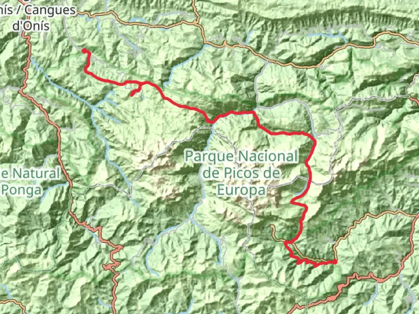
The GR 202 Ruta de la Reconquista is a 71.2 km trail that starts in Cangas de Onís, Cangas de Onís, Spain. Based on our data, the hike is graded as Extra Difficult. For information on how we grade trails, please read measuring the difficulty of a hiking trail on hiiker. Also, check our latest community posts for trail updates. This hike can be completed in approx 4 days. Caution is advised on trail times as this depends on multiple variables. For more info read about how we calculate hike time.

Frequently asked questions
What is the GR 202 Ruta de la Reconquista and where does it finish?
The GR 202 Ruta de la Reconquista is a 71.2 km multi-day hiking route through the Picos de Europa area in Asturias, starting in the Cabrales mountains and finishing at Covadonga in Cangas de Onís. It follows the historic line associated with the retreat after the Battle of Covadonga and ends at the Santa Cueva and Sanctuary of Covadonga.
How many stages does the GR 202 Ruta de la Reconquista have?
The GR 202 Ruta de la Reconquista is commonly divided into three stages: Sotres to Poncebos, Poncebos to Vega de Comeya, and Vega de Comeya to Covadonga. The published stage distances are about 11.9 km, 17.7 km, and 9.2 km respectively, while the full HiiKER route is mapped at 71.2 km overall.
How long does it take to hike the GR 202 Ruta de la Reconquista?
Most hikers should treat the GR 202 Ruta de la Reconquista as a multi-day route rather than a single long day hike. With 71.2 km of distance and 4,517 m of climbing, it sits firmly in the extra-difficult category, so a 3-day schedule is the usual minimum and some parties may prefer longer depending on pace, weather, and overnight logistics.
Is the GR 202 Ruta de la Reconquista a difficult hike?
Yes. The GR 202 Ruta de la Reconquista is rated Extra Difficult and packs 4,517 m of elevation gain into 71.2 km. That combination points to steep mountain terrain, long days, and a route better suited to experienced hikers with solid fitness and comfort in the Picos de Europa.
Does the GR 202 Ruta de la Reconquista go to the Lagos de Covadonga?
The route passes through the Covadonga Lakes area rather than simply visiting it as a short out-and-back. One of the named stages runs from Poncebos to Vega de Comeya near Lago Enol, and the final stage descends from Vega de Comeya toward Covadonga, linking the high lakes zone with the sanctuary below.
Where can you sleep on the GR 202 Ruta de la Reconquista?
Because the GR 202 Ruta de la Reconquista is a multi-day crossing, overnight planning usually centers on villages and established stopping points near stage breaks such as Sotres, Poncebos, and the Covadonga or Cangas de Onís area. The route crosses remote mountain ground, so lodging should be arranged around those access points rather than assuming services are available throughout the high sections.
Can the GR 202 Ruta de la Reconquista be hiked in 2026, and is access to Covadonga Lakes regulated?
Yes, the GR 202 Ruta de la Reconquista can be hiked in 2026, but access around the Covadonga Lakes area is seasonally managed. Asturias activated its 2026 special transport plan to the Lagos de Covadonga on March 28, 2026, with shuttle services from Cangas de Onís and regulated access toward the lakes, which can affect trailhead logistics on the Covadonga side.
Comments and Reviews
User comments, reviews and discussions about the GR 202 Ruta de la Reconquista, Spain.
average rating out of 5
0 rating(s)