Download
3D Flyover
Add to list
More
170.2 km
~8 days
6435 m
Multi-Day
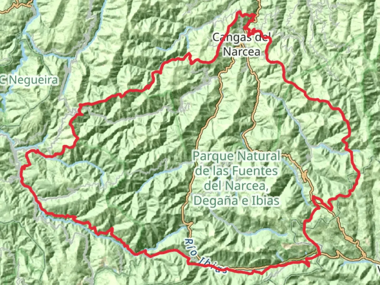
The GR 203 Por donde Camina el Oso - Asturias is a 170.2 km trail that starts in Cangas del Narcea, Cangas Del Narcea, Spain. Based on our data, the hike is graded as Extra Difficult. For information on how we grade trails, please read measuring the difficulty of a hiking trail on hiiker. Also, check our latest community posts for trail updates. This hike can be completed in approx 8 days. Caution is advised on trail times as this depends on multiple variables. For more info read about how we calculate hike time.

Frequently asked questions
How long is the GR 203 Por donde Camina el Oso - Asturias and how many days does it usually take?
GR 203 Por donde Camina el Oso - Asturias is 170.15 km long with 6,435 m of total ascent, so it is a serious multi-day route rather than a short walking trail. The route is commonly organized in stages across western Asturias, and most hikers should plan for roughly 10 to 16 days depending on pace, weather, and overnight logistics.
Is the GR 203 Por donde Camina el Oso - Asturias a difficult hike?
Yes. GR 203 Por donde Camina el Oso - Asturias is rated Extra Difficult, and the combination of 170.15 km and 6,435 m of climbing makes it a demanding long-distance trek. It is better suited to experienced hikers who are comfortable with repeated elevation gain, long days on foot, and remote mountain terrain in the Cangas del Narcea, Ibias, and Degaña area.
Where does the GR 203 Por donde Camina el Oso - Asturias go?
GR 203 Por donde Camina el Oso - Asturias runs through the southwest of Asturias and is closely associated with Cangas del Narcea. Official stage information places the route through places including Corias, Defradas, Monasterio del Coto, Seroiro, San Antolín de Ibias, Alguerdo, Sisterna, Cerredo, Leitariegos, Genestoso, El Acebo, and back toward Corias, linking the bear country of Cangas del Narcea, Ibias, and Degaña. ([fempa.net](https://fempa.net/ruta/gr-203-por-donde-camina-el-oso/?utm_source=openai))
Does the GR 203 Por donde Camina el Oso - Asturias start near Cangas del Narcea?
Yes. GR 203 Por donde Camina el Oso - Asturias is tied to Cangas del Narcea, and official stage material identifies Corias, just outside Cangas del Narcea, as a route point and the start of stage 1. That makes the Cangas del Narcea and Corias area one of the main access points for beginning the trail. ([fuentesdelnarcea.org](https://www.fuentesdelnarcea.org/gran-recorrido/gran-recorrido-203/etapa-1-courias-las-defradas_100_62_108_0_1_in.html?utm_source=openai))
What kind of terrain is on the GR 203 Por donde Camina el Oso - Asturias?
The terrain on GR 203 Por donde Camina el Oso - Asturias is varied and often rugged, with forest tracks, mountain paths, village links, and some road sections. Official stage descriptions mention chestnut woods, oak forest, river crossings, low scrub, and passes such as the collado near Tablado, as well as stretches between villages like Sisterna, Tablado, Degaña, and Cerredo. ([turismoasturias.es](https://www.turismoasturias.es/descubre/naturaleza/rutas/senderismo/por-donde-camina-el-oso?utm_source=openai))
Is the GR 203 Por donde Camina el Oso - Asturias the same as the Senda del Oso or the coastal GR routes in Asturias?
No. GR 203 Por donde Camina el Oso - Asturias is a separate inland long-distance route in bear habitat in western Asturias, centered on areas such as Cangas del Narcea, Ibias, and Degaña. It is not the Senda del Oso rail-trail near Proaza and Teverga, and it is also different from Asturias coastal routes such as the GR 204 Senda Costera. ([fempa.net](https://fempa.net/ruta/gr-203-por-donde-camina-el-oso/?utm_source=openai))
Is the GR 203 Por donde Camina el Oso - Asturias suitable for a beginner?
GR 203 Por donde Camina el Oso - Asturias is not a beginner-friendly long-distance hike. With 170.15 km of distance, 6,435 m of ascent, and an Extra Difficult rating, it is better approached by strong, well-prepared hikers with experience in multi-day mountain routes and route planning across remote parts of Asturias.
Comments and Reviews
User comments, reviews and discussions about the GR 203 Por donde Camina el Oso - Asturias, Spain.
average rating out of 5
0 rating(s)