Download
3D Flyover
Add to list
More
18.3 km
~4 hrs 55 min
755 m
Out and Back
“A steady climb to a cool, mirror-still lagoon, then a knee-testing descent through shepherded highlands.”
An 18 km (11.2 mi) out-and-back or lollipop-style mountain walk with roughly 800 m (2,625 ft) of climbing typically means a steady, aerobic day rather than anything technical—expect sustained uphill grades, a higher, cooler basin around the lagoon, and a long descent that can feel harder on knees than the climb. Plan for 5–7 hours of moving time depending on fitness, pack weight, and how long you linger at viewpoints and the water.
Getting to the start (car + public transport)
Because the trailhead location is listed only as “near” (missing the place name and coordinates), the best I can do is outline the usual approach for “Laguna de la Nava” hikes in Spain: they’re commonly accessed from a small mountain village or a signed forest track on the edge of a protected area. If you share the start coordinates (lon/lat) or the nearest town name, I can convert them to the nearest recognizable landmark/address and tailor the directions precisely.
By car - You’ll usually drive to a village-edge parking area or a signed pista forestal (gravel forest road) with a small pull-in. In these areas, parking is often informal: look for widened verges near trail signage, cattle grids, or a gate. - If the access road is unpaved, assume slow speeds and occasional ruts; after rain, some tracks become slick clay. A standard car is often fine in dry conditions, but drive cautiously and avoid blocking gates.
By public transport - Public transport in rural mountain areas is often limited to regional buses to the nearest larger town, then a taxi to the trailhead village/track. If you tell me the province/nearest town, I can suggest the most realistic bus-and-taxi combination and where you’d likely be dropped for the start.
What the route feels like (distance + climbing broken down)
With ~800 m (2,625 ft) of gain over ~18 km (11.2 mi), the day usually breaks into three clear phases:
1) Approach climb (first ~5–7 km / 3.1–4.3 mi, +450–650 m / +1,475–2,130 ft) - Expect a consistent uphill on a mix of forest track and narrower footpath, often zig-zagging to manage the grade. - Early on, you’ll likely pass stone walls, old terraces, or shepherd infrastructure (corrals, gates, watering points). These are common in upland Spain where transhumance and seasonal grazing shaped the landscape for centuries. - Underfoot: compact dirt, embedded rock, and occasional loose gravel. Trekking poles help on both the climb and the later descent.
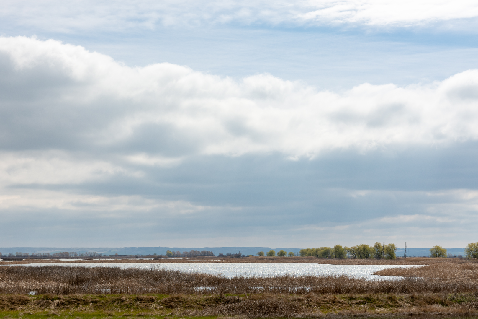
2) High basin and the lagoon (middle ~2–4 km / 1.2–2.5 mi, rolling, smaller ups/downs) - The terrain typically opens into a broad upland bowl where the lagoon sits—often a seasonal or semi-permanent wetland depending on rainfall and snowmelt. - You’ll usually get your best views here: ridgelines, open slopes, and the reflective water surface when wind is low. - The lagoon margins can be boggy. Even in dry months, expect soft ground near inflows/outflows; waterproof footwear or at least quick-drying trail shoes are a big comfort upgrade.
3) Return descent (final ~7–9 km / 4.3–5.6 mi, -800 m / -2,625 ft) - Descents on mixed gravel and hardpack can be deceptively tiring. Watch for loose stones that roll underfoot, especially on steeper shortcuts. - If the route uses a forest road for part of the return, it can feel fast but repetitive—keep an eye on junctions so you don’t drift onto a logging spur.
Landmarks, nature, and wildlife to look for
Even without the exact province, “Laguna” routes in Iberian mountain settings share a few reliable highlights:
Wetland ecology - Lagoons are biodiversity magnets. Look for reeds/sedges around the edges and a transition into heath, broom, or high pasture as you move away from the water. - Birdlife is often the star: depending on season, you may see raptors circling the thermals above the basin and water-associated birds using the lagoon as a stopover or breeding site. Keep distance from the shoreline in spring/early summer to avoid disturbing nesting areas.
Mammals and signs - In many Spanish uplands you’ll see signs of wild boar (rooted ground), roe deer tracks, and plenty of livestock (cattle, sheep, horses). If there are guardian dogs with flocks, give them space, stay calm, and pass wide without staring them down.
Flora - Expect seasonal wildflowers on open slopes, and in forested sections (if present) a mix that can include pine plantations or native woodland depending on the region. After rain, mushrooms can be abundant—admire rather than forage unless you’re experienced and local rules allow it.
Historical significance you’ll notice on the ground
Many lagoon hikes pass through landscapes shaped by: - Pastoralism and transhumance: old drovers’ routes, grazing commons, and stone-built livestock features are common. - Water management: small channels, low dams, or reinforced outflows sometimes appear where communities historically tried to stabilize water for stock and seasonal use. - Rural boundary markers: cairns, boundary stones, and long stone walls often trace municipal or grazing limits.
If you provide the nearest

Surfaces
Dirt
Unknown
Gravel
Concrete
Paved
Comments and Reviews
User comments, reviews and discussions about the Laguna de la Nava, Spain.
average rating out of 5
0 rating(s)