Download
3D Flyover
Add to list
More
10.1 km
~2 hrs 32 min
319 m
Out and Back
“Clifftop drama, cool gorge hush, and a fickle waterfall make this a rewarding hike for prepared adventurers.”
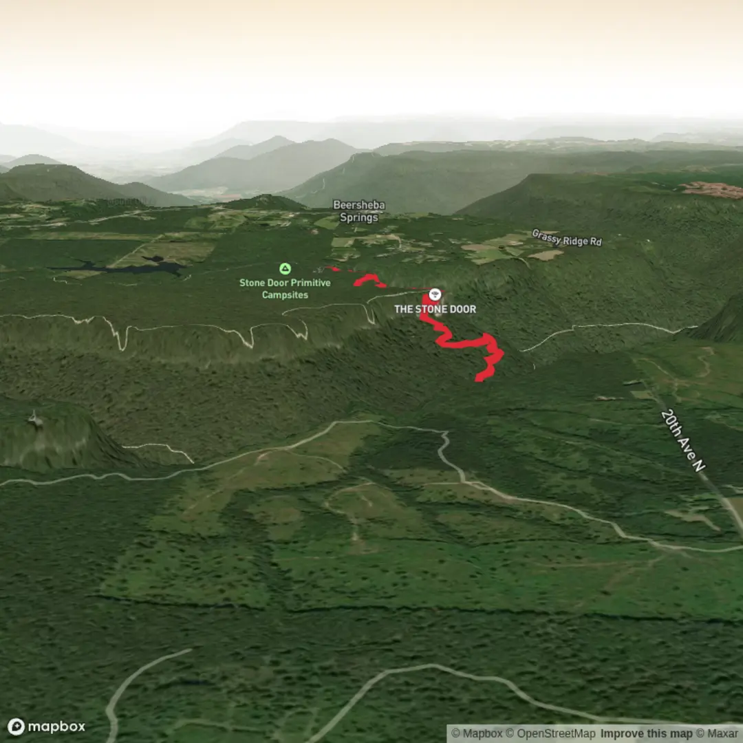
This out-and-back route to Ranger Falls is one of the more rewarding medium-grade hikes in Savage Gulf State Park, combining a dramatic plateau-edge approach, a steep descent into Big Creek Gulf, and a short side trail to a seasonal waterfall and sink. Expect roughly 10 km / 6.2 miles round trip with about 300 m / 985 ft of elevation gain overall, though the effort can feel harder than the numbers suggest because the route drops into the gulf and then requires a sustained climb back out. The hike typically begins from the Savage Gulf North / Stone Door trailhead at the Stone Door Ranger Station, whose nearest known address is 1183 Stone Door Rd, Beersheba Springs, TN 37305. Sources describing this route place the trailhead at the Stone Door Ranger Station and note the Big Creek Gulf and Ranger Falls outing at about 7 miles / 11.3 km round trip, while other trail references put the Ranger Falls side spur itself at about 0.4 miles / 0.6 km each way. (friendsofsouthcumberland.org)
From the parking area, the opening section is relatively gentle and gives hikers a chance to settle in before the terrain becomes more demanding. The route heads toward the Stone Door area, where the plateau suddenly breaks open into expansive views over Savage Gulf. This is one of the signature landscapes of the South Cumberland region: sandstone cliffs, deeply cut ravines, mixed hardwood forest, and broad seasonal vistas. After the overlook area, the trail begins its more serious descent into Big Creek Gulf, where footing becomes rockier and the grade more noticeable. The downhill is manageable for most prepared hikers, but it is the return climb that usually defines the day’s difficulty. (friendsofsouthcumberland.org)
What the route feels like
The descent into the gulf is the section to pace carefully. Stone steps, exposed roots, uneven rock, and damp patches are all common, especially after rain. Once lower in the gorge, the trail transitions into a quieter, more enclosed forest setting with hemlock-hardwood character, large boulders, creek sounds, and a cooler microclimate than the rim above. The Ranger Falls junction comes a little over 1 mile / 1.8 km beyond the main Big Creek descent according to one detailed trail guide, and the spur to the falls is short but more rugged than its mileage suggests. (cloudhiking.com)
The side trail to Ranger Falls follows a rocky drainage and may require stepping across or through the creek bed depending on recent rainfall. In drier periods, parts of this drainage can appear almost dry because water in this karst landscape can disappear underground into sinks. In wet weather, that same drainage can become hazardous. One trail source specifically warns not to proceed in high water because the crossing can become dangerous. (mountainsofadventure.com)
At Ranger Falls, hikers usually find a modest but attractive cascade framed by rock and forest rather than a huge plunge waterfall. Flow varies a lot by season and recent rain. Spring and after wet periods generally offer the best chance of seeing the falls at their most photogenic, while dry spells can reduce the flow substantially. The appeal here is not only the waterfall itself, but also the geology around it: the stream’s disappearance into the ground is part of the same sink-and-seep system that makes Savage Gulf especially interesting. (friendsofsouthcumberland.org)
Landmarks, nature, and wildlife
The most memorable landmarks on this hike are the Great Stone Door area near the start, the descent into Big Creek Gulf, the Ranger Falls junction, the rocky creek approach, and Ranger Falls itself. Some route descriptions also mention large rock formations and a notable boulder beyond the falls junction on the main Big Creek Gulf Trail, which helps give the lower gulf a rugged, sculpted feel. (friendsofsouthcumberland.org)
Savage Gulf is known for rich seasonal plant life, especially spring wildflowers and mountain laurel, along with mixed hardwood forest and shaded ravines. The broader park interpretation highlights birds, plants, and animals of the area, and the gorge environment supports the usual South Cumberland wildlife mix: songbirds, salamanders, small reptiles, white-tailed deer, and the possibility of seeing or hearing larger wildlife such as wild turkey. As with most Tennessee backcountry hikes, snakes are possible in warm months, so

Surfaces
Unknown
Ground
Paved
Comments and Reviews
User comments, reviews and discussions about the Ranger Falls via Big Creek Gulf Trail and Ranger Falls Trail, Tennessee.
average rating out of 5
0 rating(s)