Download
3D Flyover
Add to list
More
4.7 km
~1 hrs 4 min
81 m
Loop
“Woodland ease gives way to a wild, splashy gorge finale beneath Cummins Falls’ dramatic stone walls.”
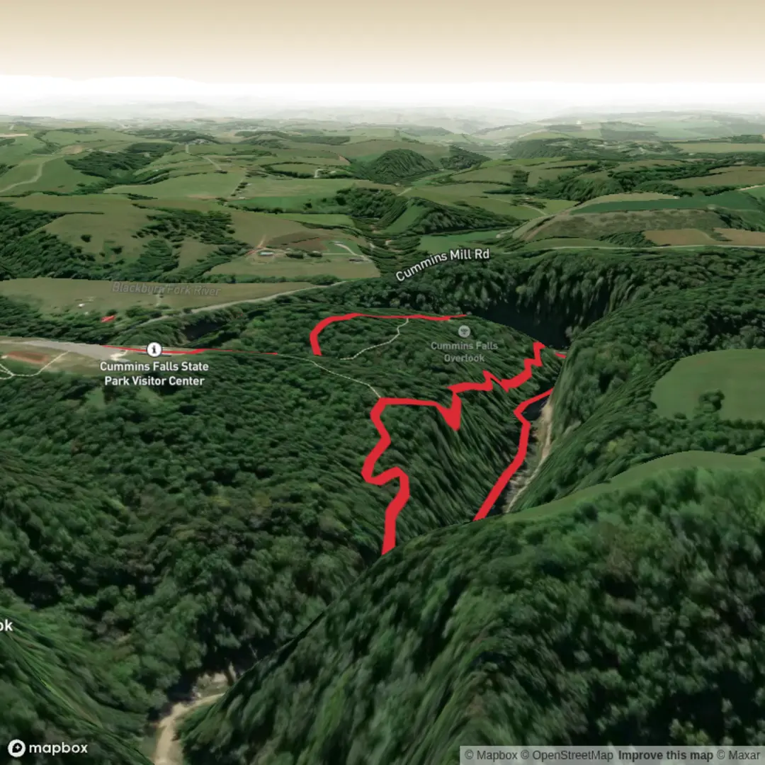
This short outing at Cummins Falls State Park packs a lot into roughly 5 km / 3.1 miles, combining easy walking on the John Cummins Trail with the more adventurous approach toward the falls area on the Falls Route. Although the overall elevation gain is only about 100 m / 330 ft, the terrain can feel more demanding than the numbers suggest because of uneven rock, roots, wet surfaces, and the river environment near the waterfall. The hike is in the park north of Cookeville, Tennessee, on the Blackburn Fork State Scenic River in the Eastern Highland Rim. (reserve.tnstateparks.com)
The nearest well-known access point is Cummins Falls State Park, 390 Cummins Falls Lane, Cookeville, TN 38501, which is the commonly used park entrance and navigation point for reaching the trailhead area. Drivers typically approach from Interstate 40 via Exit 280, then follow Highway 56 north and local roads including TN-290 and Cummins Mill Road toward the park. (waze.com)
For hikers arriving by car, this is the most practical option because the park sits in a rural area outside Cookeville and public transport to the trailhead is very limited to effectively unavailable for most visitors. The usual plan is to drive to the state park entrance, park in the designated lot, and then use HiiKER to confirm the correct trail alignment before setting out. If you are relying on public transport, the realistic approach is to travel first to Cookeville and then arrange a taxi or rideshare for the final leg, as there is no regular transit service that conveniently reaches the park entrance. This is an inference based on the park’s rural setting and published driving-focused access information. (oldmillcamp.com)
What the route is like
The walk begins in typical Highland Rim woodland, where the trail is broad and approachable compared with many waterfall hikes in Tennessee. Early on, the John Cummins Trail gives a gentler feel, with rolling terrain through mixed forest and occasional openings that hint at the gorge landscape ahead. This part is well suited to families and casual hikers, especially those who want a scenic walk without committing immediately to the rougher footing closer to the river.
As the route trends toward the falls area, the character changes. The approach becomes rockier and more irregular, and even on an “easy” day hikers should expect to slow down on slick patches, especially after rain. The waterfall itself is the defining landmark: Cummins Falls drops about 75 ft / 23 m and is recognized as one of Tennessee’s largest waterfalls by volume. The gorge setting is dramatic, with layered rock, shaded pools, and steep walls that create a cooler, enclosed microclimate around the river corridor. (reserve.tnstateparks.com)
If your planned version of the route includes going all the way to the base of the falls, preparation matters much more than the distance suggests. Tennessee State Parks warns that access to the base requires a Gorge Access Permit, is only available on fair-weather days, and involves strenuous hiking, wading or swimming, climbing rocks, and crossing slippery surfaces. The gorge is also prone to flash flooding. (reserve.tnstateparks.com)
Terrain, timing, and what to watch for
For a 5 km / 3.1 mile outing with around 100 m / 330 ft of ascent, many hikers will finish in about 1.5 to 3 hours depending on pace, water levels, and how long they spend at viewpoints or near the falls. Dry conditions make a major difference here. In wet weather, rocks in the gorge can become extremely slick, and shallow crossings can become more serious obstacles.
Footwear is one of the biggest planning points. If you are staying on the easier trail sections and overlooks, sturdy trail shoes are usually enough. If your route includes the gorge or waterfall base, shoes with strong grip that can handle water are far better than casual trainers, and Tennessee State Parks specifically advises against flip-flops for waterfall access. (reserve.tnstateparks.com)
Expect the most caution-worthy spots to be: - sloping rock near the river - muddy patches after rain - uneven roots and stone steps on descents - slick boulders near the falls - rapidly changing water conditions in the gorge
Children and less experienced hikers often do well on the easier portions of the route, but the base-of-falls section is a different undertaking entirely. The park recommends that children age 5 and under not go to the falls, and children 12 and under must wear life vests at the falls and be accompanied by an adult.

Surfaces
Ground
Unknown
Comments and Reviews
User comments, reviews and discussions about the Cummins Falls via Falls Route and John Cummins Trail, Tennessee.
average rating out of 5
0 rating(s)