Download
3D Flyover
Add to list
More
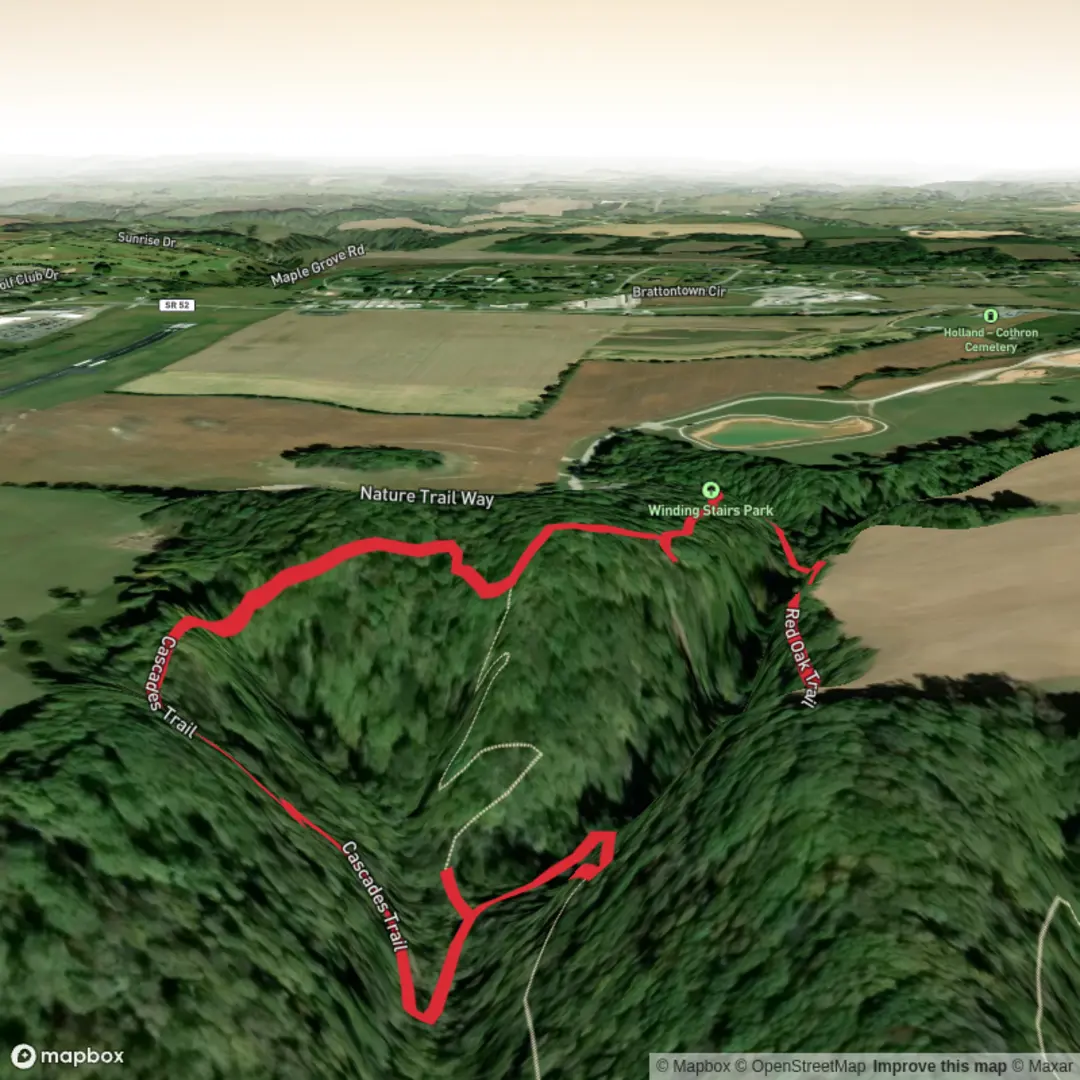
2.2 km
~33 min
65 m
Loop
“A short woodland loop with punchy climbs, shady calm, and roots that demand respectful footing.”
This short, moderately graded loop packs a surprising amount into roughly 2 km / 1.2 miles, climbing about 100 m / 330 ft overall. Expect a brief but steady outing rather than a flat stroll: the ascent comes quickly, with the Cascade Trail doing most of the climbing before the Red Oak Trail helps complete the circuit. For hikers comfortable with uneven ground and short uphill pushes, the “medium” rating makes sense. It is manageable for many walkers, but the grade, roots, and potentially slick sections can make it feel more demanding than the distance suggests.
The route is best approached as a compact woodland climb with changing terrain underfoot. Early on, the trail typically feels enclosed, with tree cover keeping the path cooler and more sheltered than open-country walks. As you gain height, the slope becomes more noticeable, and the trail can narrow in places. On a hike of this length, elevation is the main challenge, so it helps to pace the climb rather than rush it. Sturdy footwear is worthwhile even for such a short route, especially after rain when dirt, leaf litter, and exposed roots can become slippery.
What to expect on the trail
From the trailhead, the Cascade Trail usually provides the more direct uphill line. Over the first 0.8 to 1 km / 0.5 to 0.6 miles, expect most of the elevation gain, around 70 to 90 m / 230 to 295 ft, depending on the exact starting point and how the loop is walked. This section is where hikers should be ready for short steeper pitches, minor erosion, and the kind of footing that rewards careful placement on descents as much as ascents.
As the route transitions toward Red Oak Trail, the character often softens slightly. The grade tends to ease, and the walk becomes more about contouring and returning through mixed forest than pushing uphill. On a loop of this scale, the second half often passes quickly, but it is also where people can miss junctions if they are moving too fast. For navigation, using HiiKER before setting out is the best way to confirm the exact loop direction, trailhead position, and any recent access notes.
Look for mature hardwoods along the route, especially oak-dominated sections suggested by the trail name, along with seasonal understory growth. In spring and early summer, shorter forest hikes like this can be especially rewarding for wildflowers, fresh leaf-out, birdsong, and shaded creekside or drainage features if present nearby. In autumn, oak woodland routes often become more attractive still, with leaf color and a thicker carpet of fallen leaves underfoot.
Landmarks, nature, and wildlife
The main appeal here is less about a single dramatic landmark and more about the concentrated feel of a small natural pocket: a quick climb, wooded surroundings, and a sense of elevation change over a short distance. If the “Cascade” name reflects a local drainage, ravine, or small falls area, hikers should keep an eye out for rockier ground, damp hollows, and cooler microclimates near any watercourse. These spots can also be the slickest parts of the walk.
Wildlife on a trail like this is usually subtle rather than spectacular. Expect common woodland birds, squirrels, and signs of deer more often than large-animal sightings. In warmer months, insects can be active in shaded and damp sections, so repellent may be useful. In snake country, it is wise to watch where hands and feet go around rocks, logs, and sunny trail edges. After rain, amphibians may be active on the path, and muddy patches can linger longer in shaded hollows than hikers expect.
Because the route is short, many people underestimate it and bring too little water or wear casual shoes. Even on a 2 km / 1.2 mile hike, the combination of humidity, incline, and uneven footing can make the outing feel more strenuous than the mileage suggests.
Historical significance of the area
Without a confirmed trailhead location, the most responsible way to frame the history is at the landscape level. Trails with names like Cascade and Red Oak often sit in regions shaped by long Indigenous presence, followed later by timber use, small-scale farming, road building, and recreational trail development. If this hike lies in an older settled woodland park or reserve, the forest may be second-growth, meaning today’s canopy could reflect land that was once logged, grazed, or otherwise worked before returning to woodland. Oak-named trails in particular often pass through habitats that were historically important both ecologically and culturally, including for food sources, wildlife habitat, and traditional land use.
If you can share the trailhead coordinates, those can be converted to the nearest known address or landmark and tied to the specific local history of the region, whether that is Indigenous heritage, early settlement, mining, canal-era development, or conservation history.
Getting to the start
By car, the easiest approach is usually to navigate to the nearest signed park entrance, preserve access road, or trailhead parking area associated with Cascade Trail or Red Oak Trail. Since the hike details list the trail

Surfaces
Unknown
Paved
Comments and Reviews
User comments, reviews and discussions about the Southern Cascade via Cascade Trail and Red Oak Trail, Tennessee.
average rating out of 5
0 rating(s)