Download
3D Flyover
Add to list
More
19.8 km
~5 hrs 1 min
634 m
Out and Back
“Waterfalls, wild gorges, and storied overlooks make this rugged day feel grander than expected.”
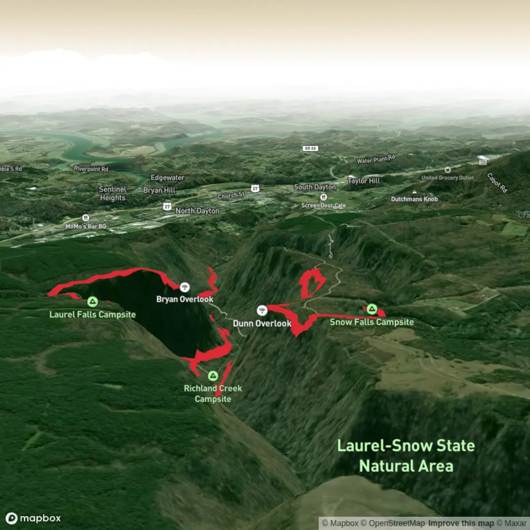
This roughly 20 km / 12.4 mile outing in Laurel-Snow State Natural Area near Dayton, Tennessee links two of the area’s signature waterfalls with a pair of dramatic overlooks, creating a route that feels much bigger than the mileage suggests. Expect a moderately strenuous day with around 600 m / 1,970 ft of cumulative climbing and descending, a mix of creekside walking, rocky spur trails, steeper plateau climbs, and several points where the terrain becomes rugged enough that footing matters more than pace. The hike begins from the Laurel-Snow State Natural Area trailhead, commonly listed near 1431 Back Valley Road, Dayton, Tennessee, in the Pocket Wilderness / Laurel-Snow area north of Dayton. (mapquest.com)
The opening section is the most straightforward. From the main parking area, the trail heads into a gorge landscape of hemlock-shaded creek corridors, sandstone outcrops, and old industrial remnants. Laurel-Snow is part of the Cumberland Trail corridor and contains Tennessee’s first National Recreation Trail, so even the approach has a long-established hiking character. The first miles are generally easier underfoot than what comes later, making them a good warm-up before the route splits toward Laurel Falls and, farther on, Snow Falls. (tn.gov)
What to expect on the route
A common way to build this hike to about 20 km / 12.4 miles is to first take the Laurel Falls spur to Bryan Overlook, then return to the main Cumberland Trail and continue out to Snow Falls with the side trip to Dunn Overlook, before retracing the route to the trailhead. Official segment distances place Laurel Falls at about 3.9 km / 2.4 miles one way, Bryan Overlook at about 5.3 km / 3.3 miles one way, and Snow Falls at about 7.7–7.9 km / 4.8–4.9 miles one way, with Dunn Overlook reached by a short side trail on the Snow Falls branch. Combined, those pieces produce a full-day hike right around your stated distance depending on exact turnarounds and any short viewpoint detours. (cumberlandtrail.org)
The Laurel Falls side is usually the more scenic early reward. After the junction, the trail climbs more decisively and becomes narrower and rougher. Laurel Falls itself drops about 24 m / 80 ft, and the trail continues beyond the base, becoming steeper and more rugged as it works up toward the plateau rim. Above the falls, there is a creek ford that can become hazardous or impassable in high water, so recent rain should change your expectations for both timing and safety. Farther along, Laurel Creek Overlook gives a look into the gorge, and Bryan Overlook marks the end of that spur. (cumberlandtrail.org)
Bryan Overlook is one of the most meaningful landmarks on the route. It is named for William Jennings Bryan, the prosecutor in the 1925 Scopes “Monkey Trial” in nearby Dayton, tying the hike directly to one of the most famous legal and cultural episodes in American history. Some maps also refer to this point as Raven Point. The overlook sits on the rim of the Cumberland Plateau and offers a broad eastward view that contrasts sharply with the enclosed creek valleys below. (cumberlandtrail.org)
Back on the main trail, the route toward Snow Falls feels more remote and more committing. After passing the Henderson Creek area and crossing the long footbridge over Richland Creek, the trail begins a longer climb. This section includes ridge travel, powerline crossings, and a short spur to Dunn Overlook, which looks out over the Henderson, Laurel, and Richland Creek gorges. Snow Falls itself is smaller than Laurel Falls at about 11 m / 35 ft, and the upper view is less dramatic than hikers often expect, though the surrounding gorge terrain and the possibility of scrambling for a better angle make it a worthwhile objective. (cumberlandtrail.org)
Terrain, difficulty, and planning notes
Although the overall rating fits a medium / moderate hike, the challenge comes from accumulated elevation change, uneven tread, and water crossings rather than from any single technical obstacle. The official Cumberland Trail description rates this section as moderately strenuous with roughly 900 ft of gain and loss on the core section, but a combined Laurel Falls–Bryan Overlook–Snow Falls–Dunn Overlook day pushes the total effort higher and makes it feel

Surfaces
Dirt
Ground
Unknown
Comments and Reviews
User comments, reviews and discussions about the Dunn Overlook, Snow Falls, Laurel Falls and Bryan Overlook, Tennessee.
average rating out of 5
0 rating(s)