Download
3D Flyover
Add to list
More
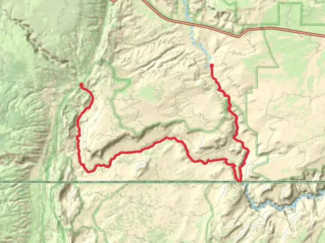
65.0 km
~3 days
1653 m
Multi-Day
“"Paria Canyon hike: a stunning 40-mile trek through history and geology for the prepared and fit."”
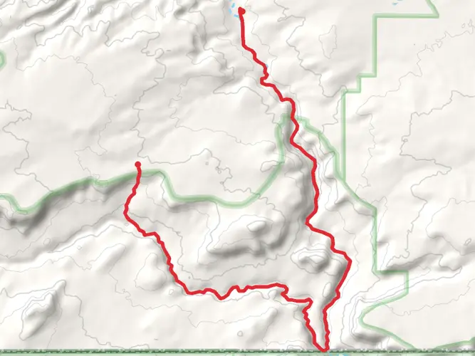
Embarking on the Paria Canyon adventure, you'll traverse approximately 40 miles (65 kilometers) through a landscape that offers a blend of challenging terrain and breathtaking scenery. With an elevation gain of around 5,250 feet (1,600 meters), hikers can expect a medium difficulty level, making it accessible to those with a reasonable level of fitness and hiking experience.
Getting to the Trailhead
The journey begins near Kane County, Utah, where the trailhead is situated. For those driving, the starting point is most conveniently reached by taking US Highway 89 to the Paria Contact Station, located between the towns of Kanab, Utah, and Page, Arizona. There is no direct public transportation to the trailhead, so hikers will need to arrange private shuttles or drive their own vehicles.
Navigating the Trail
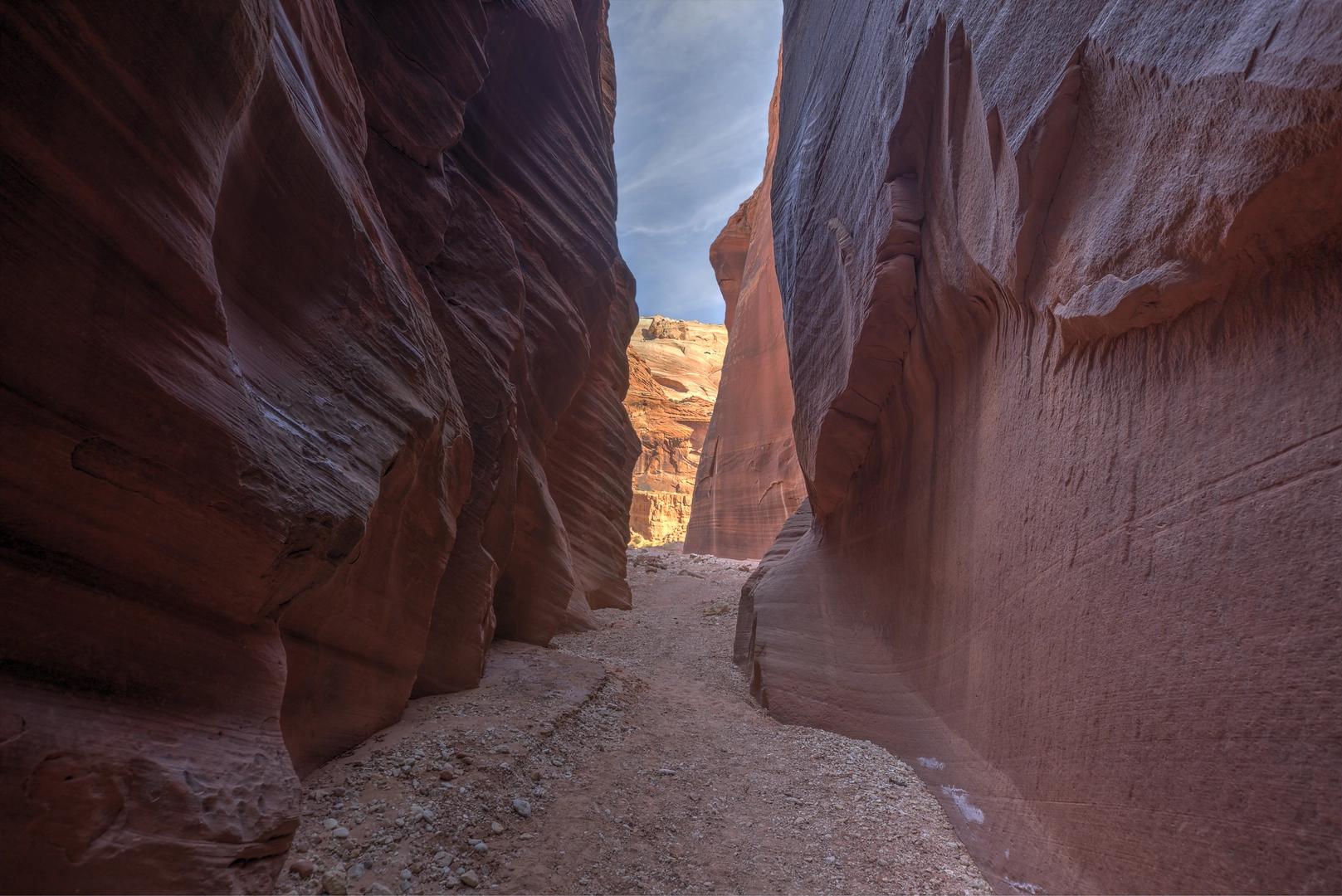
As you set out, the trail descends into the Paria Canyon, where the Paria River will be your constant companion. The route is not always well-defined, and river crossings are frequent, so waterproof footwear and trekking poles are highly recommended. Hikers should use the HiiKER app to navigate the trail, as it provides detailed maps and waypoints that are crucial for staying on course.
Landmarks and Scenery
The canyon walls, which rise hundreds of feet above, display a tapestry of reds, oranges, and purples, showcasing the geological history of the region. Notable landmarks include the confluence with Buckskin Gulch, one of the longest and deepest slot canyons in the world. This junction, about 13 miles (21 kilometers) from the trailhead, is a popular camping spot and a good place to rest before continuing.
Further along, at around the 21-mile (34-kilometer) mark, you'll encounter the impressive Wrather Arch, a hidden gem that requires a short detour to visit. The arch is a testament to the erosive power of water and time.
Flora and Fauna
The riparian habitat supports a diverse range of plant and animal life. Cottonwood trees provide shade and respite from the sun, while willows and cacti line the riverbanks. Wildlife sightings may include mule deer, bighorn sheep, and a variety of bird species, such as the endangered Southwestern willow flycatcher.
Historical Significance
The Paria Canyon area is rich in history, with evidence of ancient Native American habitation, such as petroglyphs and pictographs, which can be found on canyon walls. The region was also traversed by pioneers and settlers in the 19th century, and remnants of old homesteads and ranches are scattered throughout the landscape.
Preparation and Planning
Due to the remote nature of the trail and the potential for flash floods, hikers must be well-prepared with adequate supplies, including food, water filtration systems, and emergency gear. Permits are required for overnight trips and can be obtained from the Bureau of Land Management. It's essential to check the weather forecast and river conditions before setting out, as the canyon can become impassable after heavy rains.
The best times to hike Paria Canyon are spring and fall when temperatures are milder. Summer hikes are possible but can be extremely hot, requiring extra precautions for heat exposure.
Remember, this is a leave-no-trace area, so pack out all trash and minimize your impact on the delicate desert ecosystem. With the right preparation and respect for the environment, hiking Paria Canyon can be an unforgettable experience that offers a unique glimpse into the natural and historical tapestry of the American Southwest.

What to expect?
Activity types
Frequently asked questions
How long does it take to hike Paria Canyon end to end?
Paria Canyon is about 65.0 km, or 40 miles, and most backpackers take 3 to 5 days to complete it as a point-to-point trip. The route is difficult, with about 1,653 m of elevation gain, frequent walking in the Paria River, and many wet, sandy, and rocky sections that slow progress.
Do you need a permit for an overnight hike in Paria Canyon?
Yes. Overnight trips in Paria Canyon require a Paria Canyon Overnight Permit, and use is limited. The Bureau of Land Management manages entry through trailheads including White House, Wire Pass, Buckskin Gulch, and Lees Ferry, so permits should be secured before travel dates are set.
Where do most hikers start and finish the Paria Canyon hike?
Most full-length Paria Canyon trips are done as a shuttle hike, commonly starting at White House Trailhead and finishing at Lees Ferry. Another popular variation enters through Wire Pass, follows Buckskin Gulch to its confluence with the Paria, then continues down Paria Canyon to Lees Ferry.
Is Paria Canyon hard to hike even though the elevation gain is moderate?
Yes. Paria Canyon is rated difficult not just because of its 1,653 m of climbing, but because the route involves repeated river crossings, wet footing, deep sand, mud, and sections where the path is faint or braided. The canyon setting also makes pace slower than the 65.0 km distance might suggest.
When is the best time of year to hike Paria Canyon?
Spring and fall are generally the best seasons for Paria Canyon because temperatures are cooler and more manageable for a multi-day desert trip. Summer brings much higher heat and a serious flash-flood risk, especially in narrow canyon sections and around the Buckskin Gulch confluence.
Can dogs go on the Paria Canyon hike?
Dogs are generally not allowed on Paria Canyon overnight trips in the Paria Canyon-Vermilion Cliffs Wilderness permit area. That matters on a 65.0 km multi-day route where entry is controlled and camps are regulated, so pet plans usually need to be changed before the trip.
Is there parking and public transportation for Paria Canyon?
There is trailhead parking for Paria Canyon access points such as White House, but there is no direct public transportation to the route. Because the hike is usually done point to point between trailheads like White House or Wire Pass and Lees Ferry, many parties arrange a private shuttle or use two vehicles.
Comments and Reviews
User comments, reviews and discussions about the Paria Canyon, Utah.
4.63
average rating out of 5
8 rating(s)