Download
3D Flyover
Add to list
More
28.8 km
~5 hrs 57 min
117 m
Multi-Day
“Embark on a historical and nature-filled journey along the Potomac on the picturesque Mount Vernon Trail.”
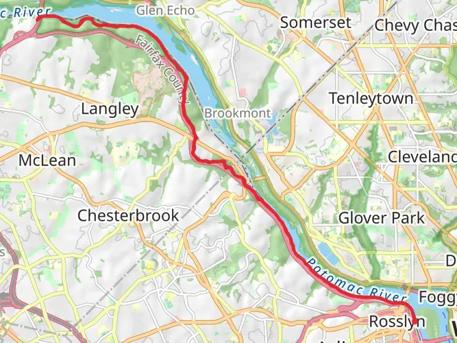
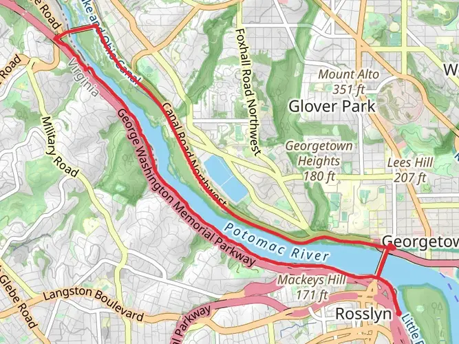
The Mount Vernon Trail is a scenic multi-use path that stretches approximately 18 miles (29 km) along the Potomac River, offering a relatively flat journey with an elevation gain of around 328 feet (100 meters). Starting near Roosevelt Island in Arlington County, Virginia, the trail meanders southward to George Washington's historic estate at Mount Vernon.
Getting to the Trailhead
To reach the trailhead near Arlington County, you have a few options. If driving, you can park at the Theodore Roosevelt Island parking lot, which is accessible from the northbound lanes of the George Washington Memorial Parkway. For those opting for public transportation, the Rosslyn Metro station is the closest, and from there, it's a short walk to the trailhead. Cyclists can also easily access the trail from various points in Arlington and Alexandria.
Navigating the Trail
As you embark on the Mount Vernon Trail, you'll find it well-maintained and clearly marked, making it easy to follow without the need for advanced navigation tools. However, for those who prefer digital assistance, the HiiKER app provides detailed maps and trail information that can enhance the hiking experience.
Landmarks and Historical Significance
The trail offers a mix of natural beauty and historical landmarks. One of the first significant sites is the Lady Bird Johnson Park, where you can enjoy wildflowers and the Lyndon Baines Johnson Memorial Grove. As you continue, you'll pass Gravelly Point, a popular spot for watching airplanes take off and land at the nearby Ronald Reagan Washington National Airport.
Further along, the trail takes you through Old Town Alexandria, a neighborhood known for its well-preserved 18th- and 19th-century architecture and cobblestone streets. Here, you can take a detour to explore local shops, restaurants, and historical sites like the Torpedo Factory Art Center.
The trail also features several bridges, including the Woodrow Wilson Bridge, which offers a panoramic view of the Potomac River. As you approach Mount Vernon, the trail becomes more wooded and serene, providing a peaceful conclusion to the journey.
Nature and Wildlife
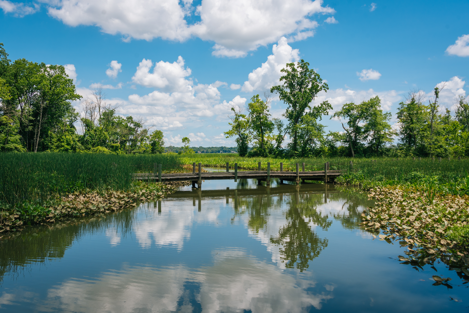
Throughout the trail, hikers can enjoy a variety of ecosystems, from urban waterfronts to tidal wetlands and hardwood forests. Birdwatchers will appreciate the diverse birdlife, including ospreys, herons, and bald eagles. Spring and fall migrations bring additional species to the area, making these seasons particularly rewarding for birding enthusiasts.
Preparation and Planning
Before setting out, it's important to prepare for the trail's length and to plan for rest stops or points of interest you may want to visit. The trail is mostly flat and paved, making it accessible for hikers of all skill levels, as well as cyclists and runners. There are water fountains and restrooms spaced along the route, but it's wise to carry water and snacks, especially on warmer days.
Remember to check the weather forecast and dress appropriately, as the trail offers limited shade. Sunscreen and a hat are recommended for sunny days. Lastly, be mindful of the trail's multi-use nature and share the path courteously with other users.
By following these guidelines and taking advantage of the resources available, such as the HiiKER app for trail maps and information, your experience on the Mount Vernon Trail is sure to be enjoyable and memorable.

What to expect?
Activity types
Frequently asked questions
How long is the Mount Vernon Trail and how much climbing does the Mount Vernon Trail have?
The Mount Vernon Trail is 28.82 km long, or about 18 miles, with roughly 117 m of elevation gain. It is a mostly flat route along the Potomac River, which is why it is generally rated easy despite its point-to-point length.
Where does the Mount Vernon Trail start and finish?
The Mount Vernon Trail runs between the Rosslyn area in Arlington County and George Washington’s Mount Vernon estate south of Alexandria. The north end is reached near Theodore Roosevelt Island and Gateway Park, while the south end is at Mount Vernon on the George Washington Memorial Parkway corridor.
Where can you park for the Mount Vernon Trail in Arlington County?
A common Arlington County access point for the Mount Vernon Trail is the Theodore Roosevelt Island parking lot on the northbound side of the George Washington Memorial Parkway. At the southern end, George Washington’s Mount Vernon also has free visitor parking, which makes either end practical for a one-way or out-and-back day.
Can you get to the Mount Vernon Trail by Metro?
Yes. Rosslyn Metro is one of the easiest rail access points for the Mount Vernon Trail, and Theodore Roosevelt Island is about a 10-minute walk from Rosslyn. The trail also connects near Reagan National Airport, giving another useful transit-linked access point farther south.
Is the Mount Vernon Trail dog friendly?
The Mount Vernon Trail allows dogs, but pets must stay leashed. That makes it a practical easy-grade walk for hikers with dogs, especially on shorter sections near Theodore Roosevelt Island, Gravelly Point, or the Alexandria waterfront.
What are the main landmarks on the Mount Vernon Trail?
The Mount Vernon Trail passes several well-known Potomac-side landmarks, including Theodore Roosevelt Island, Lady Bird Johnson Park, Gravelly Point, Old Town Alexandria, Jones Point Park, Daingerfield Island, and George Washington’s Mount Vernon. One of the most distinctive stretches is Gravelly Point, where the trail runs beside Reagan National Airport with close-up views of arriving and departing aircraft.
Is the Mount Vernon Trail suitable for beginners or kids?
The Mount Vernon Trail is generally suitable for beginners because it is rated easy and gains only about 117 m over 28.82 km. Families often choose shorter out-and-back sections rather than the full route, especially around Roosevelt Island, Gravelly Point, or Alexandria, where access is straightforward and the terrain stays gentle.
Comments and Reviews
User comments, reviews and discussions about the Mount Vernon Trail, Virginia.
4.71
average rating out of 5
14 rating(s)