Download
3D Flyover
Add to list
More
8.5 km
~2 hrs 18 min
367 m
Out and Back
“Climb into Shenandoah Mountain’s hushed hardwood ridge, where fleeting openings reward steady effort.”
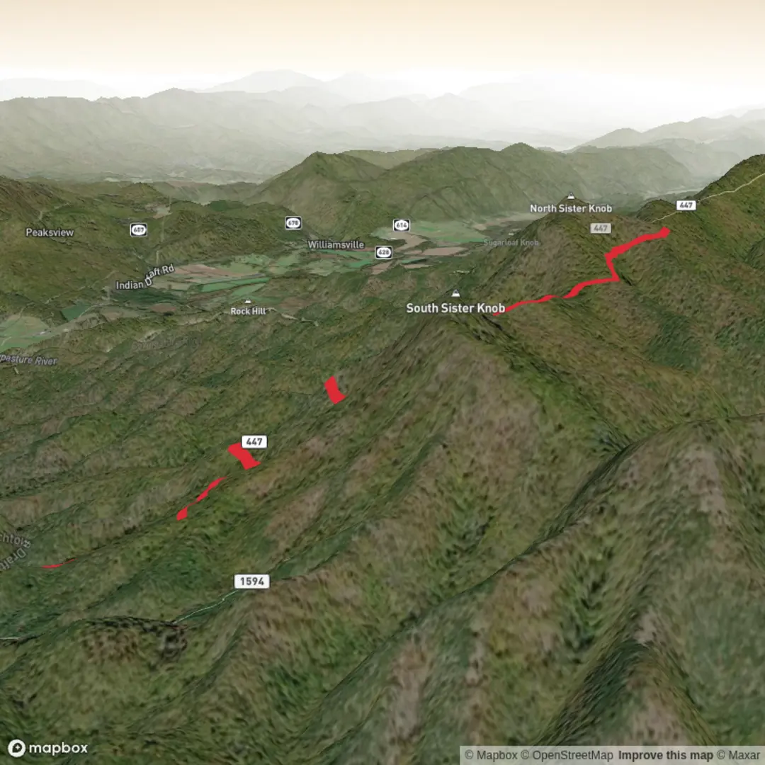
This medium-effort out-and-back climbs onto the long ridge of Shenandoah Mountain (the Virginia–West Virginia border ridge) to reach North Sister Knob, a high, forested summit area around 1,002 m / 3,287 ft. (topozone.com) With ~9 km / 5.6 mi total distance and ~400 m / 1,312 ft of gain, expect a steady climb, a few short steeper pitches, and classic ridge-top walking through mixed Appalachian hardwoods with occasional openings.
Getting to the trailhead (car + public transport options)
Most practical start point: the Shenandoah Mountain Trail North (Forest TR #102) trailhead on the crest of Shenandoah Mountain, commonly used for hikes toward High Knob and the ridge system. (fs.usda.gov)
Because your hike details list the start only as “near” (no coordinates provided), the best “nearest known landmark” to anchor planning is:
- Landmark: Reddish Knob area / Shenandoah Mountain crest (George Washington National Forest). Reddish Knob is a well-known high point on this ridge with a parking area and access to multiple ridge trails/roads. (en.wikipedia.org)
By car:
Plan for mountain roads (often gravel/rough in places depending on which approach you use). Cell service can be unreliable on the ridge. Use HiiKER to confirm the exact trailhead pin, road numbers, and any seasonal access notes before you drive up.
By public transport:
There’s no direct transit to the ridge-top trailheads. The workable approach is:
1) Take intercity rail/bus to a nearby Shenandoah Valley city (commonly Harrisonburg or Staunton), then
2) Use a rideshare/taxi to reach the forest roads/trailhead.
Be aware: last-mile rides can be hard to book and expensive because the start is remote; arrange a pickup plan in advance (or go with two vehicles).
What the hike feels like, step by step
0.0–1.5 km (0.0–0.9 mi): settling into the climb
From the ridge-access trailhead, you’ll be on a forest trail that quickly commits to uphill travel. The tread is typically dirt with embedded rock and leaf litter; after rain it can be slick, especially where the trail channels water. Early on, you’ll be in shaded woods—great in summer, but it can feel cooler and windier than the valley.
1.5–3.5 km (0.9–2.2 mi): ridge approach and navigation checks
As you gain height, the grade often eases into more “ridge-like” walking—still climbing overall, but with short flatter stretches that make the elevation gain feel manageable. This is where it’s easy to drift at junctions or on faint connectors if you’re not watching closely. Keep HiiKER open and confirm each junction as you go, especially if you encounter old roadbeds or side paths.
3.5–4.5 km (2.2–2.8 mi): final push to North Sister Knob
The last segment typically feels more enclosed and “summit-forest” like—mossier ground, thicker understory in spots, and fewer long views right at the knob itself (many Appalachian knobs are wooded). Expect the high point to be subtle: a rise in the ridge rather than a dramatic rocky summit.
Turn around at the knob and retrace your route for a total ~9 km / 5.6 mi.
Landmarks, scenery, and what to watch for
- Ridge ecology: Shenandoah Mountain’s crest supports mixed hardwood forest with seasonal wildflowers; spring and early summer can be especially lush along the ridge roads and openings. (friendsofshenandoahmountain.org)

Comments and Reviews
User comments, reviews and discussions about the North Sister Knob via Shenandoah Mountain Trail, Virginia.
average rating out of 5
0 rating(s)