Download
Preview
Add to list
More
6.0 km
~1 hrs 17 min
58 m
Loop
“Follow shaded, rooty paths to roaring Great Falls—clifftop vistas and river ledges reward attentive steps.”
You’ll be walking the Virginia side of Great Falls Park (part of the George Washington Memorial Parkway), threading together two of the park’s best riverside paths: the Potomac Trail (higher, woodsy, and a bit more rooty) and the River Trail (closer to the water with frequent gorge views). At roughly 6 km / 3.7 mi with about 100 m / 330 ft of total climbing, it’s an easy outing by fitness level, but it has a few places where footing and exposure near the river deserve real attention.
Getting to the start (car + public transport reality)
Start area (nearest landmark/address): the main Great Falls Park visitor area on the Virginia side, near Great Falls Park Visitor Center, 9200 Old Dominion Dr, McLean, VA. (aaa.com)
By car: Drive to Great Falls Park and park in the main lots by the visitor center/overlooks. The park charges an entrance fee (commonly $20 per vehicle, and it’s cashless as of Jan 1, 2025). (nps.gov)
Cell service can be spotty in and around the gorge, so download your route in HiiKER before you arrive.
By public transport: Great Falls Park is not on public transportation routes, and the National Park Service notes there’s no access to public transportation from the park by foot or bicycle. Plan on driving, rideshare, or a private shuttle. (nps.gov)
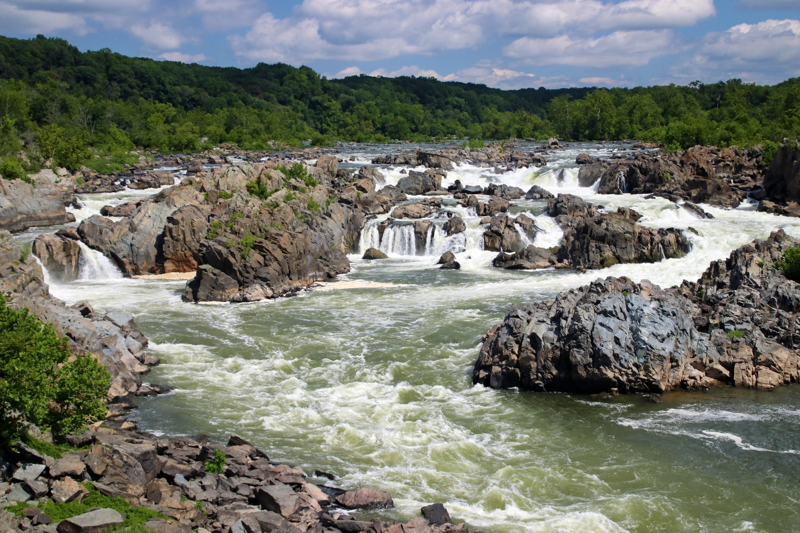
From the visitor center area, you’ll quickly reach the famous overlooks where the Potomac compresses and drops through a series of cataracts into Mather Gorge. The sound of the falls is a constant backdrop here, and the first 0.5–1.0 km (0.3–0.6 mi) tends to be the busiest because it overlaps with overlook foot traffic.
Once you commit to the loop, the character changes: the tread narrows, the crowds thin, and you begin alternating between clifftop viewpoints and river-level ledges. Expect a mix of packed dirt, exposed roots, and short rocky steps—nothing long or steep, but enough to keep you watching your feet.
What the terrain feels like (and where the “easy” rating can bite)
Most of the elevation gain (that ~100 m / 330 ft) comes in small pulses: short climbs away from the river, then gentle rollers through forest. The Potomac Trail portion typically feels more “inland”—shadier, more rooty, and a little more uneven—while the River Trail stays closer to the gorge rim and water, delivering the best continuous scenery. The River Trail in this park is specifically noted as running along the Potomac in scenic Mather Gorge on the Virginia side. (nps.gov)
Even on an easy loop, there are a few consistent hazards here: - Cliff-edge exposure: there are sections where the trail runs close to drop-offs above the river. Keep kids close and dogs leashed. - Slippery rock near the water: spray and humidity can slick up stone, especially near overlooks and informal rock perches. - High water after storms: the Potomac can rise fast; avoid stepping onto low rocks or “beachy” ledges if the river looks pushy.
Use HiiKER to stay on the intended line—there are social paths near viewpoints that can pull you toward the edge or into dead ends.
Landmarks, nature, and what to look for
Great Falls + Mather Gorge: The signature views come where the river narrows and accelerates into the gorge. Geologically, this is the Fall Line zone—where the Potomac transitions between the Piedmont and the Atlantic Coastal Plain—and the falls/gorge formed as the river exploited weaker rock zones and eroded into its current channel. (nps.gov)
Forest and river ecology: You’ll move through mixed hardwood forest typical of the Potomac Gorge corridor. Wildlife sightings vary by season and time of day, but it’s common to notice: - Songbirds and woodpeckers in the upland woods - Raptors riding thermals above the gorge - White-tailed deer deeper in the trees - Turtles and waterfowl in calmer river margins (where visible)
**

Surfaces
Ground
Unpaved
Gravel
Wood
Unknown
Asphalt
Comments and Reviews
User comments, reviews and discussions about the Great Falls via Potomac Trail and River Trail, Virginia.
average rating out of 5
0 rating(s)