Download
3D Flyover
Add to list
More
22.5 km
~5 hrs 56 min
871 m
Point-to-Point
“A long, ridge-and-gap wander from hushed forest to breezy stone views, weather-permitting.”
This is a longer, ridge-and-gap style day hike of roughly 22 km (13.7 mi) with about 900 m (2,950 ft) of climbing—steady enough to feel “Medium” only if you’re comfortable being on your feet for 6–8+ hours and managing a few sustained ascents. Expect a mix of forested trail, open viewpoints from higher ground, and a couple of places where weather and footing can change the character of the day quickly.
Getting to the start (car + public transport options)
Because the hike head is listed only as “near” (no coordinates or place name provided), I can’t reliably convert the start point to a nearest address/landmark yet. If you share a lon/lat (or even the nearest town/park entrance), I’ll translate it to the closest recognizable landmark and tailor the approach directions precisely.
In the meantime, here’s how this typically works for a Stone Mountain–named trailhead in the U.S. (there are several “Stone Mountain” areas across different states):
- By car: Most Stone Mountain trailheads are reached via a signed park road leading to a main day-use parking area (often near a visitor contact point, picnic area, or campground). Arrive early—longer loop hikes that link multiple features (like a gap + butte) often share parking with shorter, popular summit walks.
- By public transport: Public transit is often limited for mountain trailheads. The most realistic option is usually bus/train to the nearest town, then a taxi/rideshare to the park entrance or main trailhead parking. If you tell me the state/nearest town, I can outline the most practical transit chain.
What the route feels like (pace, terrain, and effort)
At 22 km (13.7 mi) and 900 m (2,950 ft), the effort usually comes in two or three main climbs rather than one continuous grind. Plan for: - Early gentle warm-up on packed dirt and leaf litter, often with roots and occasional rock steps. - A longer mid-route ascent where the grade becomes more consistent and you start gaining the bulk of the elevation. - Shorter punchy rises as you move between the “gap” and “butte” features—these can feel surprisingly taxing late in the day.
Footing commonly alternates between: - Firm singletrack in the woods - Rocky sections (ankle-turners if you’re tired) - Exposed stone on higher ground that can be slick when wet or frosty
If you’re using a navigation app, load the route in HiiKER and download it for offline use—these longer link-ups often have junctions where a wrong turn costs real time and energy.
Landmarks and natural highlights you’re likely to encounter
Even without the exact trailhead location, the names strongly suggest a classic sequence:
- Low Gap: “Gap” usually indicates a saddle—a lower pass between higher points. These areas can be breezy and cooler, and they’re common junction zones where multiple trails converge. Gaps are also natural funnels for weather; fog can roll in fast, and wind can spike even on otherwise calm days.
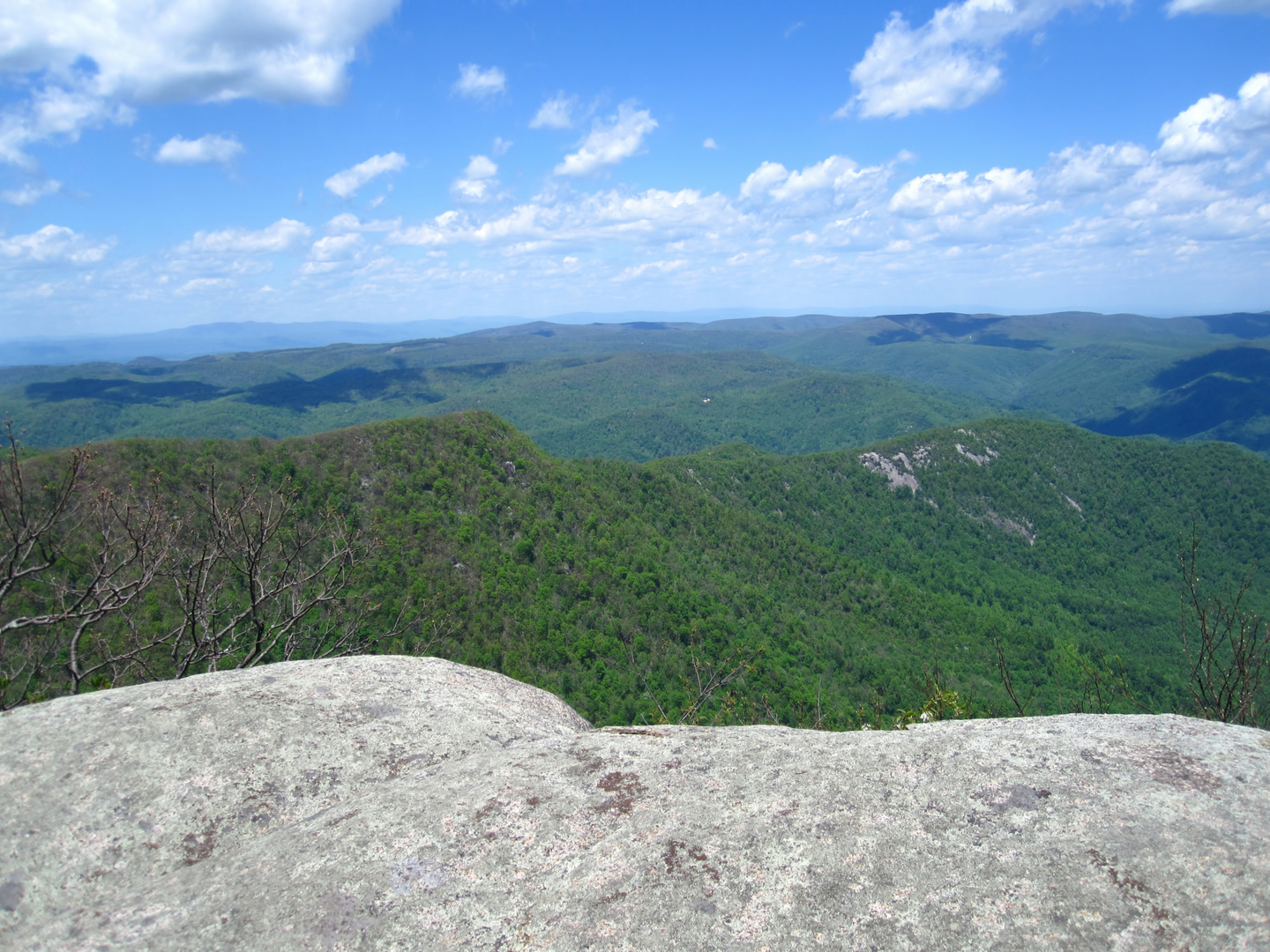
- High Butte: A “butte” is typically a prominent, steep-sided high point with a more open crown or shoulder. Expect your best long-range views here if the route breaks out of the forest canopy. Buttes often have rocky, exposed edges—great for scenery, but pay attention to footing and keep a buffer from drop-offs, especially in gusty conditions.
- Stone Mountain Trail segments: Trails with this name frequently traverse granite or other exposed bedrock, with sections that feel like walking on a tilted sidewalk. In wet conditions, that rock can become slick; in hot sun, it can radiate heat and increase dehydration risk.
Wildlife, plants, and seasonal conditions
What you’ll see depends heavily on which Stone Mountain region this is, but for many U.S. mountain-forest environments on a medium-length ridge route, plan for:
- Birdlife: raptors riding thermals near open viewpoints; songbirds in the forested stretches.
- Mammals: deer are common; smaller mammals (squirrels, chipmunks) around gaps and picnic-like areas. In some regions, black bears are possible—carry food securely and follow local guidance.
- Reptiles/insects: in warm months, watch for ticks in grassy edges and leaf litter; in rocky sunny sections, snakes may bask near trail margins.
- Seasonal hazards:
- Spring: muddy patches, swollen creeks, and slick rock.
- Summer: heat exposure on open stone; thunderstorms can make exposed high points risky.
- Fall: leaf cover can hide rocks/roots; shorter daylight.
- Winter/shoulder season: ice on shaded rock and in gaps; wind chill on exposed butte areas.
Key things to look out for (safety + comfort)
- Water planning: For a 22 km (13.7 mi) day with ~900 m (2,950 ft) gain, many hikers carry 2–3 L depending on temperature and whether reliable water sources exist. If the route crosses streams, treat water—don’t assume it’s safe.
- Weather exposure: The “butte” and any open stone can be fully exposed. Bring a wind layer even on mild days; pack a rain shell if storms are possible.
- Navigation at junctions: Gaps often have multiple trail spurs. Confirm each turn in HiiKER before committing—especially if there are un

Surfaces
Dirt
Unknown
Comments and Reviews
User comments, reviews and discussions about the Low Gap and High Butte via Stone Mountain Trail, Virginia.
average rating out of 5
0 rating(s)