Download
3D Flyover
Add to list
More
13.7 km
~3 hrs 44 min
598 m
Loop
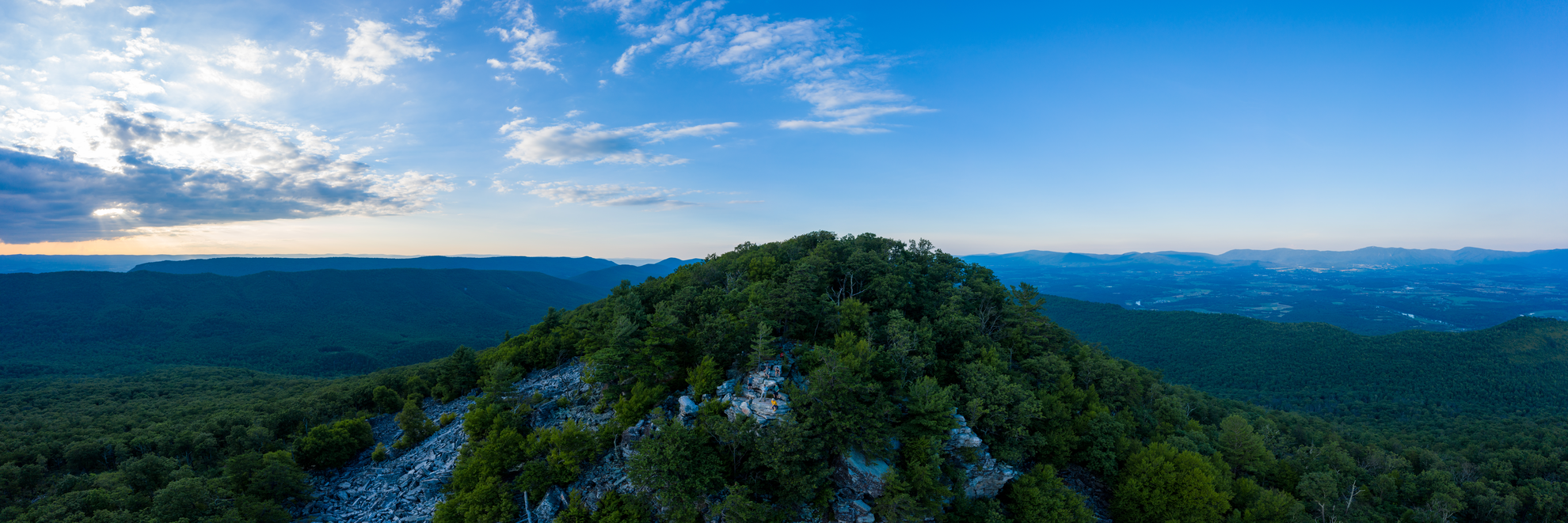
“A forested climb through Scothorn Gap opens onto Duncan Knob’s rocky perch—earned views, mindful footing.”
A medium, ridge-and-gap hike with a steady climb to a rocky summit viewpoint, this route covers about 14 km (8.7 mi) with roughly 600 m (1,970 ft) of total ascent. Expect a mix of shaded forest walking, a sustained uphill push through a mountain gap, and a more open, rockier feel as you near Duncan Knob—plus a few short, steeper pitches where you’ll want to pace yourself.
Getting to the trailhead (car + public transport options)
By car: This hike is in Virginia’s Massanutten range area (Shenandoah Valley). The most practical approach is to drive to the nearest established trail access/parking associated with the Scothorn Gap / Massanutten Trail network in the George Washington National Forest / Massanutten region, typically reached from the Fort Valley / Luray / Front Royal side depending on the exact start point used for your loop/out-and-back. If you share the lon/lat for the start, I can convert it to the nearest recognizable landmark/road access and describe the exact approach and parking situation.
By public transport: Public transit is limited in this area. The most workable “mostly-transit” plan is: - Take intercity rail/bus to a larger hub such as Front Royal, VA area (or Harrisonburg, VA depending on where you’re coming from), - Then use a taxi/rideshare to reach the forest road/trail access point. Because service coverage can be spotty in the valley and very limited once you’re in the forest, plan on pre-booking a ride and having a backup pickup plan.
What the hike feels like, section by section
0.0–3.5 km (0.0–2.2 mi) | Gentle warm-up, then the climb begins (≈150–250 m / 490–820 ft gain)
The opening miles are typically the most forgiving: packed dirt, leaf litter, and a gradual grade under hardwood canopy. In spring and early summer, look for wildflowers along the edges and listen for songbirds; in fall, the leaf drop can hide rocks and roots, so foot placement matters. As you approach the gap, the trail begins to tilt upward more consistently—still hikeable, but you’ll notice your breathing rate climb.
3.5–6.5 km (2.2–4.0 mi) | Scothorn Gap climb: sustained, steady work (≈250–350 m / 820–1,150 ft gain)
This is the “earn it” portion. The grade tends to be sustained rather than brutally steep, but it’s long enough to punish fast starts. Expect:
- Switchbacks or contouring climbs depending on the exact alignment,
- Occasional rocky steps and short eroded pitches,
- A cooler, damper feel in shaded hollows—watch for slick leaves after rain.
If you’re using HiiKER, this is a good place to check your progress against the elevation profile so you can manage effort and hydration before the ridge walking begins.
Ridge travel and the Massanutten Trail character
6.5–9.0 km (4.0–5.6 mi) | Ridge undulations and navigation attention (≈100–200 m / 330–650 ft gain)
Once you’re up near the ridge system, the walking often becomes a rhythm of short climbs and dips. The Massanutten Trail corridor can alternate between:
- Narrow singletrack with rocks embedded in the tread,
- Brief stretches that feel more open with scrub and mountain laurel,
- Occasional side paths or old woods roads—easy to second-guess if you’re not watching blazes/signs.
Keep an eye out for rocky outcrops and small clearings that offer partial views into the Shenandoah Valley. In dry periods, ridge sections can feel surprisingly warm and exposed compared to the shaded climb.
Duncan Knob: the main landmark
9.0–10.0 km (5.6–6.2 mi) | Final approach to the knob (≈50–100 m / 165–330 ft gain)
The last kilometer often becomes rockier, with a more “mountain-top” feel—thin soils, more stone underfoot, and a sense of opening up. Duncan Knob itself is known for prominent rock and viewpoint potential. Wind can be stronger here, and temperatures can be noticeably cooler than at the trailhead.
Plan to spend time carefully choosing where to step on the rocks—especially if there’s moisture, frost, or leaf cover. If you’re hiking with a group, this is also where spacing helps: people tend to stop abruptly for views and photos.
Return leg (loop or out-and-back)
10.0–14.0 km (6.2–8.7 mi) | Descent management (≈300–450 m / 980–1,480 ft descent overall)
However the route returns—either retracing or completing a loop—the descent is where knees and ankles take the most load. Common issues:
- Loose gravel/ball-bearing rocks on steeper pitches,
- Leaf-slick tread in autumn,
- Mud in low spots after rain.
Trekking poles can help a lot here, and it’s worth checking HiiKER for any alternate junctions so you don’t accidentally follow a more gradual woods road that leads away from your intended finish.
Terrain, conditions, and what to watch for
- Footing: Expect a mix of dirt, roots, and rock. The ridge and knob area can be especially rocky.

Surfaces
Dirt
Ground
Comments and Reviews
User comments, reviews and discussions about the Duncan Knob via Scothorn Gap Trail and Massanutten Trail, Virginia.
average rating out of 5
0 rating(s)