Download
3D Flyover
Add to list
More
7.0 km
~1 hrs 26 min
25 m
Loop
“Stroll through quiet woods and open parkland, where gentle paths whisper Civil War stories.”
A mostly level, easy-going walk of about 7 km (4.3 miles) with ~0 m / ~0 ft of climbing, this route is ideal for a relaxed half-day outing where the focus is on history, quiet woods, and open parkland rather than elevation or technical footing. Expect a mix of packed dirt, mown grass, and short paved or hard-packed connectors, with frequent opportunities to pause at interpretive points if you’re in or near Spotsylvania’s battlefield/heritage areas.
Getting to the start (car + public transport)
Because the start point you provided is incomplete (“near …”), the most reliable way to plan is to anchor your arrival to a major, well-known access point in the Spotsylvania historic corridor:
- By car: Most hikers approach Spotsylvania’s historic trail networks via the Spotsylvania Court House / Fredericksburg area. A common landmark to navigate to is Spotsylvania Courthouse Battlefield (part of the Fredericksburg & Spotsylvania National Military Park)—from there, you can choose the closest trailhead/parking area shown on HiiKER for the exact loop you’re doing. Parking is typically in designated lots near battlefield stops and trail access points; arrive earlier on weekends when heritage tourism is busiest.
- By public transport: The most practical transit hub is usually Fredericksburg (VRE/Amtrak station). From there, you’ll generally need a rideshare/taxi to reach the trail access points around Spotsylvania Court House and the battlefield units (public buses in the region can be limited and may not align well with trailhead locations). Use HiiKER to pick the trailhead closest to a named battlefield stop, then plug that into your rideshare.
If you share the lon/lat (or a pin) for “Hike head: near …”, I can convert it to the nearest known address or landmark and tailor the directions precisely.
What the walk feels like underfoot You’ll be on gentle grades almost the entire time—any “ups and downs” are usually subtle rolls in the terrain rather than true climbs. Footing is generally straightforward, but plan for: - Short muddy stretches after rain (especially in shaded woods and low spots) - Roots and uneven ground in forested sections - Occasional narrower singletrack where vegetation can brush your legs in warmer months
Even with minimal elevation gain, this is still a “watch your step” hike in places—easy doesn’t always mean perfectly smooth.
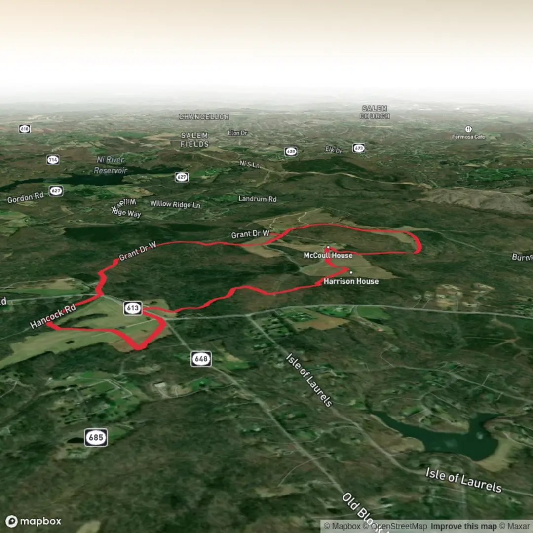
Landmarks and historical context
Spotsylvania is closely tied to the American Civil War, especially the 1864 Overland Campaign, when the region saw intense fighting, field fortifications, and prolonged engagements. Many trails in the area pass near: - Earthworks and trench lines (often low, linear berms that can be easy to miss if you’re not looking for them) - Clearings and old road traces that once served as troop routes and supply lines - Interpretive signage at key points explaining troop movements and the significance of particular positions
If your 7 km route is within the main battlefield units, you may encounter places associated with the Battle of Spotsylvania Court House—a landscape where the “quiet woods” today contrast sharply with the area’s past. Treat any earthworks as protected resources: stay on the tread, don’t climb on fragile features, and avoid cutting corners that widen the path.
Nature, scenery, and wildlife to look out for
The environment here is typically mixed woodland with patches of open ground—good for bird activity and seasonal wildflowers.
Common things to notice: - Hardwood forest edges where sunlight encourages undergrowth and flowering plants in spring - Songbirds and woodpeckers in the trees; listen for repeated tapping and calls along quieter stretches - White-tailed deer are common, especially early and late in the day - Ticks and mosquitoes can be significant in warm months—use repellent and do a full tick check afterward
You may also see snakes (often non-aggressive and more interested in avoiding you than interacting). Give them space, especially on warm days when they may be on or near the trail.
Pacing and planning (distance markers you can use) For a 7 km (4.3 mi) easy route, a typical hiking pace (including stops) often looks like: - 1.5–2 hours moving time - 2–3 hours total if you stop to read signs, take photos, or explore short spurs
A simple way to break it up: - 0–2 km (0–1.2 mi): Settle in, confirm you’re on the intended track, and note the first major junctions. - 2–5 km (1.2–3.1 mi): The “core” of the walk—this is where you’ll usually find the most continuous wooded walking and the best chance of encountering interpretive points. - 5–7 km (3.1–4.3 mi): Return leg—fatigue is low, but attention can drift; keep an eye out for turns that lead back to parking.
Navigation and on-trail decision points Even in flat historic parks, trails can braid together with short connectors, old roadbeds, and interpretive spurs. Use HiiKER to: - Download the route for offline use before you arrive (cell service can be inconsistent in wooded pockets) - Watch for junction density—the most common “wrong turn” is taking a spur that looks equally worn - Confirm you’re returning to the correct parking area

Surfaces
Ground
Unknown
Paved
Unpaved
Comments and Reviews
User comments, reviews and discussions about the Spotsylvania Historical Trail, Virginia.
average rating out of 5
0 rating(s)