Download
Preview
Add to list
More
41.0 km
~3 days
1262 m
Multi-Day
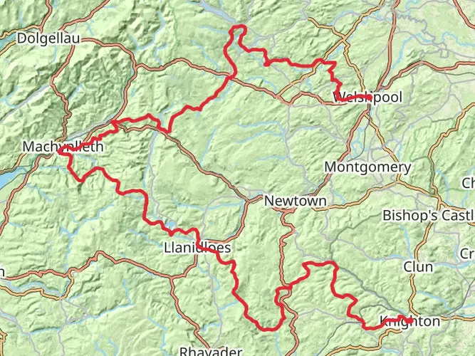
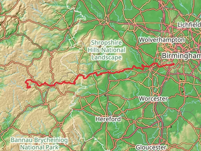
The Llanidoes Loop is a 41.0 km trail that starts in , Powys, Wales. Based on our data, the hike is graded as Medium. For information on how we grade trails, please read measuring the difficulty of a hiking trail on hiiker. Also, check our latest community posts for trail updates. This hike can be completed in approx 2 days. Caution is advised on trail times as this depends on multiple variables. For more info read about how we calculate hike time.

What to expect?
Activity types
Frequently asked questions
How long does the Llanidoes Loop usually take to hike?
The Llanidoes Loop is 40.96 km long with 1,262 m of elevation gain, so it is usually treated as a two-day hike rather than a short day walk. Strong hikers may cover it in a long single day, but the multi-day classification and medium difficulty make an overnight plan the more realistic option for most people.
Is the Llanidoes Loop a difficult walk or is the Llanidoes Loop suitable for intermediate hikers?
The Llanidoes Loop is rated medium difficulty, but it is still a serious route at just under 41 km with 1,262 m of climbing. That puts it in a range better suited to hikers with decent fitness and some experience pacing longer days over mixed Welsh terrain rather than complete beginners.
Can the Llanidoes Loop be done as a day hike, or is the Llanidoes Loop better as an overnight trip?
The Llanidoes Loop can be done in a day by very fit hikers, but the numbers favor an overnight itinerary for most people. At 40.96 km with 1,262 m of ascent, it is long enough to feel more like a weekend route, especially in shorter daylight months or in wet conditions common in Powys.
Where do you start the Llanidoes Loop, and is there parking in Llanidloes for the Llanidoes Loop?
The route is associated with Llanidloes in Powys, so the practical start point is in or near Llanidloes itself. Llanidloes is a market town with town-center parking and local access roads, which makes it a sensible base for a loop walk, but exact parking choice depends on the intended start street or trail access point on the day.
Can you reach the Llanidoes Loop by public transport from Llanidloes or nearby stations?
Yes, public transport is possible, though it usually involves reaching Llanidloes first. Llanidloes no longer has its own railway station, and Caersws on the Cambrian Line is commonly used as the nearest railhead for the town; Powys bus services also operate locally, including hail-and-ride outside towns.
Is the Llanidoes Loop dog friendly?
Dogs can generally be taken on public rights of way in Powys, but they must be kept under close control, and extra care is needed around sheep and other livestock. On a long rural route like the Llanidoes Loop, that means a lead is the safest default whenever stock are present in fields or on open hillside.
What should you know before hiking the Llanidoes Loop in Powys, Wales?
The key facts are the scale and effort: the Llanidoes Loop is 40.96 km long, gains 1,262 m, and is classed as a medium multi-day route. In practical terms, that means planning for a full-day or overnight outing, carrying layers for changeable Mid Wales weather, and allowing extra time if the ground is wet or visibility is poor.
Comments and Reviews
User comments, reviews and discussions about the Llanidoes Loop, Wales.
4.37
average rating out of 5
38 rating(s)