Download
Preview
Add to list
More
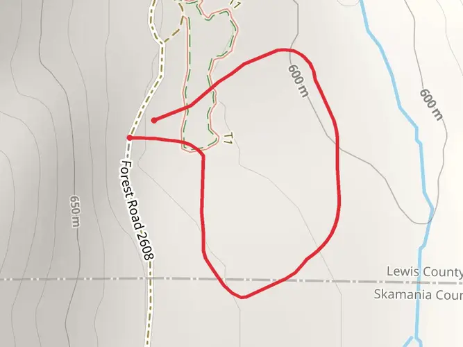
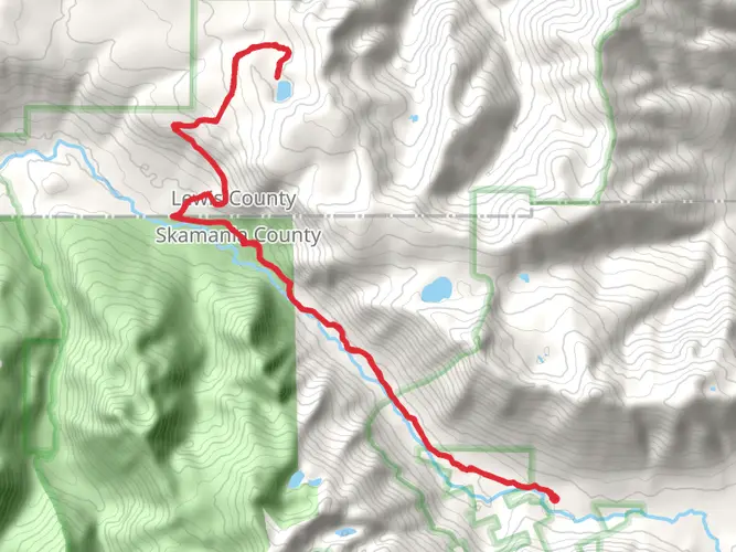
27.7 km
~2 days
1389 m
Multi-Day
“Embark on a breathtaking 28-kilometer trek through the historic volcanic vistas of Mount St. Helens.”
Embarking on the Northern Mount St. Helens Loop, hikers will traverse approximately 28 kilometers (about 17.4 miles) of rugged terrain with an elevation gain of around 1300 meters (approximately 4265 feet). This challenging loop trail is situated near Lewis County, Washington, and is known for its breathtaking views and the historical significance of Mount St. Helens.
Getting to the Trailhead
To reach the trailhead, if you're driving, you'll want to head towards the Windy Ridge Viewpoint on Forest Road 99. This area is accessible by taking State Route 504 east from Castle Rock to Forest Road 99, then heading north. For those relying on public transport, options are limited due to the remote nature of the area, so a car rental might be necessary.
Navigating the Trail
As you set out on the trail, it's essential to have a reliable navigation tool. HiiKER is a recommended app for this purpose, providing detailed maps and GPS tracking to ensure you stay on the right path.
Landmarks and Nature
The trail offers a mix of landscapes, from dense forests recovering from the 1980 eruption to vast pumice plains and wildflower meadows. The first section of the hike will take you through the humbling blast zone where the power of the eruption is still evident. You'll witness the regrowth of nature as you pass by the Harmony Trail, which leads to Spirit Lake, approximately 4.8 kilometers (3 miles) from the trailhead.
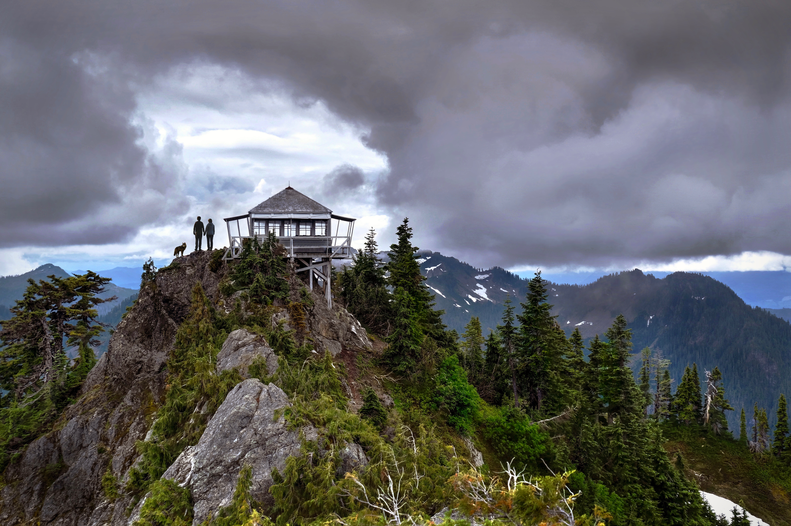
As you ascend, you'll encounter the Plains of Abraham, a stark yet beautiful expanse of pumice and ash with Mount St. Helens looming in the background. This is a great spot to observe the volcano's crater and the surrounding peaks of the Cascade Range.
Wildlife and Flora
The area is home to a variety of wildlife, including elk, black bears, and mountain goats. Birdwatchers may spot the American dipper, peregrine falcon, and the occasional golden eagle. The trail also winds through patches of noble fir and mountain hemlock, with wildflowers like lupine and Indian paintbrush adding splashes of color in the summer months.
Historical Significance
Mount St. Helens is a living testament to the Earth's volcanic activity. The 1980 eruption was one of the most significant geological events in recent U.S. history, dramatically altering the landscape. The trail offers several vantage points to view the crater and the lava dome, which continues to grow.
Preparation and Safety
Given the trail's difficulty, it's crucial to be well-prepared with adequate supplies, including water, food, and layers for changing weather conditions. The elevation gain can be strenuous, so ensure you're in good physical condition before attempting this hike. It's also wise to check for any trail closures or conditions with the local ranger station before setting out.
Remember, safety is paramount. Always let someone know your itinerary and expected return time. The Northern Mount St. Helens Loop is a challenging but rewarding hike that offers a unique glimpse into the power of nature and the resilience of the environment.

What to expect?
Activity types
Frequently asked questions
How long does the Northern Mount St Helens Loop take to hike?
The Northern Mount St Helens Loop covers 27.72 km, or about 17.4 miles, with 1,389 meters of elevation gain, so it is a full-day effort for strong hikers and is often treated as an overnight route. On this terrain, many parties should expect roughly 8 to 12 hours of moving time, depending on pace, weather, and how long they stop at viewpoints around Spirit Lake and the blast zone.
Where do you start the Northern Mount St Helens Loop and where can you park?
The usual access is from the Windy Ridge area on Forest Road 99 in the Mount St. Helens National Volcanic Monument. Windy Ridge Viewpoint has a developed parking area and interpretive site, and it is one of the main east-side access points for hikes in this part of the monument, with views toward the crater and Spirit Lake.
Is the Northern Mount St Helens Loop hard?
Yes. The Northern Mount St Helens Loop is rated difficult, and the numbers explain why: 27.72 km of hiking with 1,389 meters, or about 4,557 feet, of climbing. The route crosses exposed volcanic terrain near Windy Ridge, the Harmony Trail area, and the Plains of Abraham, where sun, wind, and loose footing can make the day feel harder than the mileage alone suggests.
When is the best time of year to hike the Northern Mount St Helens Loop?
The best window is usually summer into early fall, when Forest Road 99 and Windy Ridge are typically snow-free and open. East-side access to Windy Ridge is commonly closed until late June or early July because of snow, so this is not a dependable spring hike. Later summer usually offers the most reliable access and the clearest views across Spirit Lake and the crater.
Are dogs allowed on the Northern Mount St Helens Loop?
Dogs are not a good fit for this route. Parts of the northern Mount St. Helens trail system fall within restricted zones of the national volcanic monument where pets are prohibited, and the exposed pumice, sharp volcanic rock, and long mileage add extra risk even where access rules differ by segment. Checking current monument rules before setting out is important.
Can you camp on the Northern Mount St Helens Loop?
The Northern Mount St Helens Loop is listed as a multi-day route, but camping is not allowed along Forest Road 99 within the national volcanic monument corridor itself. That means an overnight plan needs to account for where camping is legally permitted outside the road corridor and any restricted-zone rules that apply on the north side of Mount St. Helens.
What landmarks do you see on the Northern Mount St Helens Loop?
This loop is known for major eruption-landscape landmarks rather than forest-only scenery. The route area includes Windy Ridge, Spirit Lake, the Harmony Trail corridor, and the Plains of Abraham, with broad views into the 1980 blast zone and toward Mount St. Helens itself. It is one of the most dramatic places in Washington to see how the volcano reshaped the landscape.
Comments and Reviews
User comments, reviews and discussions about the Northern Mount St Helens Loop, Washington.
4.64
average rating out of 5
11 rating(s)